You are here: Home > Network List > US - United States National Seismic Network Stations List
> Station LONY Lake Ozonia, New York, USA > Earthquake Result Viewer
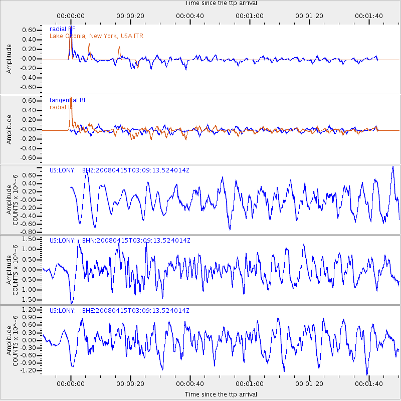
LONY Lake Ozonia, New York, USA - Earthquake Result Viewer
*The percent match for this event was below the threshold and hence no stack was calculated.
| Earthquake location: |
Near Coast Of Guatemala |
| Earthquake latitude/longitude: |
13.6/-90.6 |
| Earthquake time(UTC): |
2008/04/15 (106) 03:03:04 GMT |
| Earthquake Depth: |
33 km |
| Earthquake Magnitude: |
5.6 MB, 5.8 MS, 6.1 MW, 6.1 MW |
| Earthquake Catalog/Contributor: |
WHDF/NEIC |
|
| Network: |
US United States National Seismic Network |
| Station: |
LONY Lake Ozonia, New York, USA |
| Lat/Lon: |
44.62 N/74.58 W |
| Elevation: |
440 m |
|
| Distance: |
33.8 deg |
| Az: |
20.725 deg |
| Baz: |
208.809 deg |
| Ray Param: |
$rayparam |
*The percent match for this event was below the threshold and hence was not used in the summary stack. |
|
| Radial Match: |
77.481606 % |
| Radial Bump: |
366 |
| Transverse Match: |
62.269413 % |
| Transverse Bump: |
360 |
| SOD ConfigId: |
2504 |
| Insert Time: |
2010-03-05 07:24:00.249 +0000 |
| GWidth: |
2.5 |
| Max Bumps: |
400 |
| Tol: |
0.001 |
|
Signal To Noise
| Channel | StoN | STA | LTA |
| US:LONY: :BHN:20080415T03:09:13.524014Z | 4.936199 | 9.798898E-7 | 1.9851099E-7 |
| US:LONY: :BHE:20080415T03:09:13.524014Z | 4.093881 | 6.331104E-7 | 1.5464798E-7 |
| US:LONY: :BHZ:20080415T03:09:13.524014Z | 0.67513937 | 2.0612427E-7 | 3.0530626E-7 |
| Arrivals |
| Ps | |
| PpPs | |
| PsPs/PpSs | |


