You are here: Home > Network List > US - United States National Seismic Network Stations List
> Station LONY Lake Ozonia, New York, USA > Earthquake Result Viewer
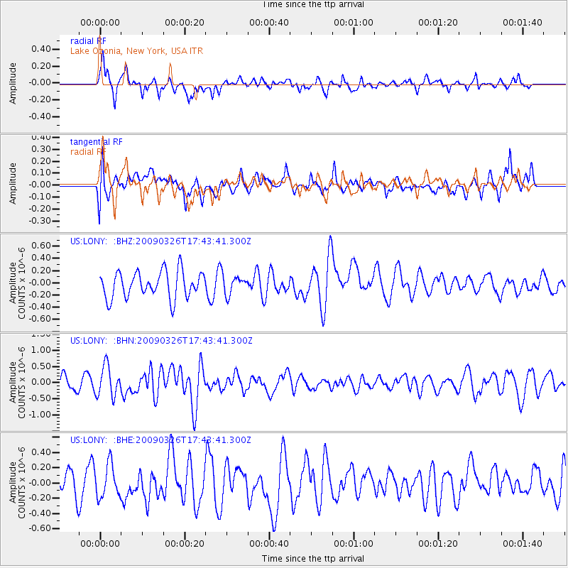
LONY Lake Ozonia, New York, USA - Earthquake Result Viewer
*The percent match for this event was below the threshold and hence no stack was calculated.
| Earthquake location: |
Near Coast Of Northern Peru |
| Earthquake latitude/longitude: |
-5.7/-81.3 |
| Earthquake time(UTC): |
2009/03/26 (085) 17:35:14 GMT |
| Earthquake Depth: |
10 km |
| Earthquake Magnitude: |
5.6 MB, 5.5 MS, 5.8 MW, 5.7 MW |
| Earthquake Catalog/Contributor: |
WHDF/NEIC |
|
| Network: |
US United States National Seismic Network |
| Station: |
LONY Lake Ozonia, New York, USA |
| Lat/Lon: |
44.62 N/74.58 W |
| Elevation: |
440 m |
|
| Distance: |
50.5 deg |
| Az: |
6.252 deg |
| Baz: |
188.728 deg |
| Ray Param: |
$rayparam |
*The percent match for this event was below the threshold and hence was not used in the summary stack. |
|
| Radial Match: |
74.861206 % |
| Radial Bump: |
400 |
| Transverse Match: |
60.603706 % |
| Transverse Bump: |
400 |
| SOD ConfigId: |
2658 |
| Insert Time: |
2010-03-05 07:24:43.156 +0000 |
| GWidth: |
2.5 |
| Max Bumps: |
400 |
| Tol: |
0.001 |
|
Signal To Noise
| Channel | StoN | STA | LTA |
| US:LONY: :BHN:20090326T17:43:41.300Z | 2.4103887 | 4.77057E-7 | 1.9791702E-7 |
| US:LONY: :BHE:20090326T17:43:41.300Z | 1.087482 | 2.2014122E-7 | 2.0243206E-7 |
| US:LONY: :BHZ:20090326T17:43:41.300Z | 0.65045696 | 1.4062817E-7 | 2.1619903E-7 |
| Arrivals |
| Ps | |
| PpPs | |
| PsPs/PpSs | |


