You are here: Home > Network List > CO - South Carolina Seismic Network Stations List
> Station HODGE CO:HODGE > Earthquake Result Viewer
HODGE CO:HODGE - Earthquake Result Viewer
| Earthquake location: |
Southeast Of Easter Island |
| Earthquake latitude/longitude: |
-35.6/-103.9 |
| Earthquake time(UTC): |
2016/09/29 (273) 00:21:09 GMT |
| Earthquake Depth: |
10 km |
| Earthquake Magnitude: |
5.5 Mwc |
| Earthquake Catalog/Contributor: |
NEIC PDE/us |
|
| Network: |
CO South Carolina Seismic Network |
| Station: |
HODGE CO:HODGE |
| Lat/Lon: |
34.23 N/82.26 W |
| Elevation: |
151 m |
|
| Distance: |
72.4 deg |
| Az: |
18.699 deg |
| Baz: |
198.381 deg |
| Ray Param: |
0.053714033 |
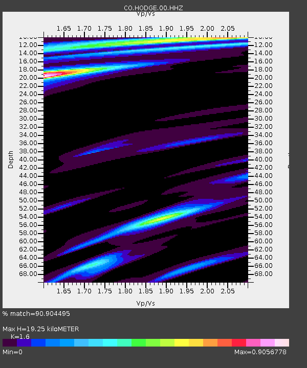
| Estimated Moho Depth: |
19.25 km |
| Estimated Crust Vp/Vs: |
1.60 |
| Assumed Crust Vp: |
6.35 km/s |
| Estimated Crust Vs: |
3.969 km/s |
| Estimated Crust Poisson's Ratio: |
0.18 |
|
| Radial Match: |
90.904495 % |
| Radial Bump: |
352 |
| Transverse Match: |
86.993195 % |
| Transverse Bump: |
299 |
| SOD ConfigId: |
11737051 |
| Insert Time: |
2019-04-25 16:07:32.376 +0000 |
| GWidth: |
2.5 |
| Max Bumps: |
400 |
| Tol: |
0.001 |
|

Signal To Noise
| Channel | StoN | STA | LTA |
| CO:HODGE:00:HHZ:20160929T00:32:04.179006Z | 0.9338534 | 2.0057134E-7 | 2.1477818E-7 |
| CO:HODGE:00:HHN:20160929T00:32:04.179006Z | 0.7772556 | 1.9063638E-7 | 2.4526858E-7 |
| CO:HODGE:00:HHE:20160929T00:32:04.179006Z | 1.1558617 | 2.0152825E-7 | 1.7435325E-7 |
| Arrivals |
| Ps | 1.9 SECOND |
| PpPs | 7.6 SECOND |
| PsPs/PpSs | 9.5 SECOND |


