You are here: Home > Network List > AK - Alaska Regional Network Stations List
> Station MDM Murphy Dome > Earthquake Result Viewer
MDM Murphy Dome - Earthquake Result Viewer
*The percent match for this event was below the threshold and hence no stack was calculated.
| Earthquake location: |
Tonga Islands Region |
| Earthquake latitude/longitude: |
-23.7/-174.9 |
| Earthquake time(UTC): |
2016/10/01 (275) 00:33:04 GMT |
| Earthquake Depth: |
35 km |
| Earthquake Magnitude: |
5.6 MWC, 5.6 MWC |
| Earthquake Catalog/Contributor: |
NEIC PDE/NEIC COMCAT |
|
| Network: |
AK Alaska Regional Network |
| Station: |
MDM Murphy Dome |
| Lat/Lon: |
64.96 N/148.23 W |
| Elevation: |
634 m |
|
| Distance: |
90.7 deg |
| Az: |
11.013 deg |
| Baz: |
204.294 deg |
| Ray Param: |
$rayparam |
*The percent match for this event was below the threshold and hence was not used in the summary stack. |
|
| Radial Match: |
59.71262 % |
| Radial Bump: |
334 |
| Transverse Match: |
26.677906 % |
| Transverse Bump: |
400 |
| SOD ConfigId: |
11737051 |
| Insert Time: |
2019-04-25 16:16:34.533 +0000 |
| GWidth: |
2.5 |
| Max Bumps: |
400 |
| Tol: |
0.001 |
|
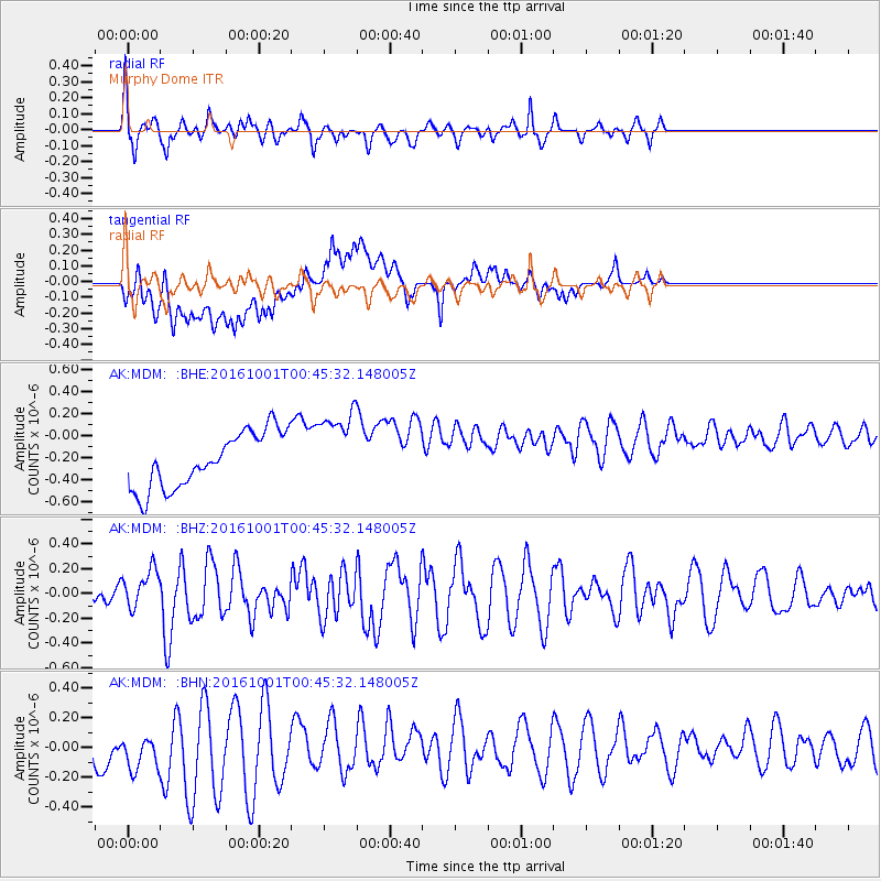
Signal To Noise
| Channel | StoN | STA | LTA |
| AK:MDM: :BHZ:20161001T00:45:32.148005Z | 1.5174896 | 1.5319588E-7 | 1.0095351E-7 |
| AK:MDM: :BHN:20161001T00:45:32.148005Z | 1.2058816 | 1.8402532E-7 | 1.5260646E-7 |
| AK:MDM: :BHE:20161001T00:45:32.148005Z | 1.4544138 | 3.7030674E-7 | 2.5460892E-7 |
| Arrivals |
| Ps | |
| PpPs | |
| PsPs/PpSs | |


