You are here: Home > Network List > CI - Caltech Regional Seismic Network Stations List
> Station DGR Domenigoni Reservoir, California, USA > Earthquake Result Viewer
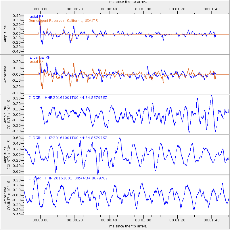
DGR Domenigoni Reservoir, California, USA - Earthquake Result Viewer
*The percent match for this event was below the threshold and hence no stack was calculated.
| Earthquake location: |
Tonga Islands Region |
| Earthquake latitude/longitude: |
-23.7/-174.9 |
| Earthquake time(UTC): |
2016/10/01 (275) 00:33:04 GMT |
| Earthquake Depth: |
35 km |
| Earthquake Magnitude: |
5.6 MWC, 5.6 MWC |
| Earthquake Catalog/Contributor: |
NEIC PDE/NEIC COMCAT |
|
| Network: |
CI Caltech Regional Seismic Network |
| Station: |
DGR Domenigoni Reservoir, California, USA |
| Lat/Lon: |
33.65 N/117.01 W |
| Elevation: |
609 m |
|
| Distance: |
79.3 deg |
| Az: |
45.978 deg |
| Baz: |
232.203 deg |
| Ray Param: |
$rayparam |
*The percent match for this event was below the threshold and hence was not used in the summary stack. |
|
| Radial Match: |
63.33391 % |
| Radial Bump: |
363 |
| Transverse Match: |
64.78863 % |
| Transverse Bump: |
400 |
| SOD ConfigId: |
11737051 |
| Insert Time: |
2019-04-25 16:18:03.961 +0000 |
| GWidth: |
2.5 |
| Max Bumps: |
400 |
| Tol: |
0.001 |
|
Signal To Noise
| Channel | StoN | STA | LTA |
| CI:DGR: :HHZ:20161001T00:44:34.867976Z | 1.3647671 | 1.3723213E-7 | 1.0055353E-7 |
| CI:DGR: :HHN:20161001T00:44:34.867976Z | 1.6532297 | 1.8488063E-7 | 1.11829976E-7 |
| CI:DGR: :HHE:20161001T00:44:34.867976Z | 1.6353899 | 1.17633114E-7 | 7.1929705E-8 |
| Arrivals |
| Ps | |
| PpPs | |
| PsPs/PpSs | |


