You are here: Home > Network List > TA - USArray Transportable Network (new EarthScope stations) Stations List
> Station H24K Noodor Dome, AK, USA > Earthquake Result Viewer
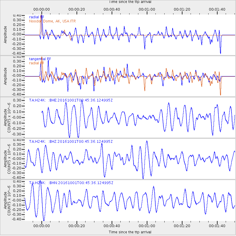
H24K Noodor Dome, AK, USA - Earthquake Result Viewer
*The percent match for this event was below the threshold and hence no stack was calculated.
| Earthquake location: |
Tonga Islands Region |
| Earthquake latitude/longitude: |
-23.7/-174.9 |
| Earthquake time(UTC): |
2016/10/01 (275) 00:33:04 GMT |
| Earthquake Depth: |
35 km |
| Earthquake Magnitude: |
5.6 MWC, 5.6 MWC |
| Earthquake Catalog/Contributor: |
NEIC PDE/NEIC COMCAT |
|
| Network: |
TA USArray Transportable Network (new EarthScope stations) |
| Station: |
H24K Noodor Dome, AK, USA |
| Lat/Lon: |
65.84 N/147.88 W |
| Elevation: |
814 m |
|
| Distance: |
91.6 deg |
| Az: |
10.781 deg |
| Baz: |
204.618 deg |
| Ray Param: |
$rayparam |
*The percent match for this event was below the threshold and hence was not used in the summary stack. |
|
| Radial Match: |
52.981194 % |
| Radial Bump: |
400 |
| Transverse Match: |
69.13969 % |
| Transverse Bump: |
252 |
| SOD ConfigId: |
11737051 |
| Insert Time: |
2019-04-25 16:22:01.685 +0000 |
| GWidth: |
2.5 |
| Max Bumps: |
400 |
| Tol: |
0.001 |
|
Signal To Noise
| Channel | StoN | STA | LTA |
| TA:H24K: :BHZ:20161001T00:45:36.124995Z | 1.6597862 | 1.8691354E-7 | 1.1261302E-7 |
| TA:H24K: :BHN:20161001T00:45:36.124995Z | 1.8688873 | 2.7250832E-7 | 1.4581313E-7 |
| TA:H24K: :BHE:20161001T00:45:36.124995Z | 0.8111297 | 1.3110152E-7 | 1.616283E-7 |
| Arrivals |
| Ps | |
| PpPs | |
| PsPs/PpSs | |


