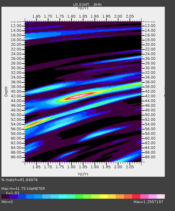
EGMT Eagleton, Montana, USA - Earthquake Result Viewer
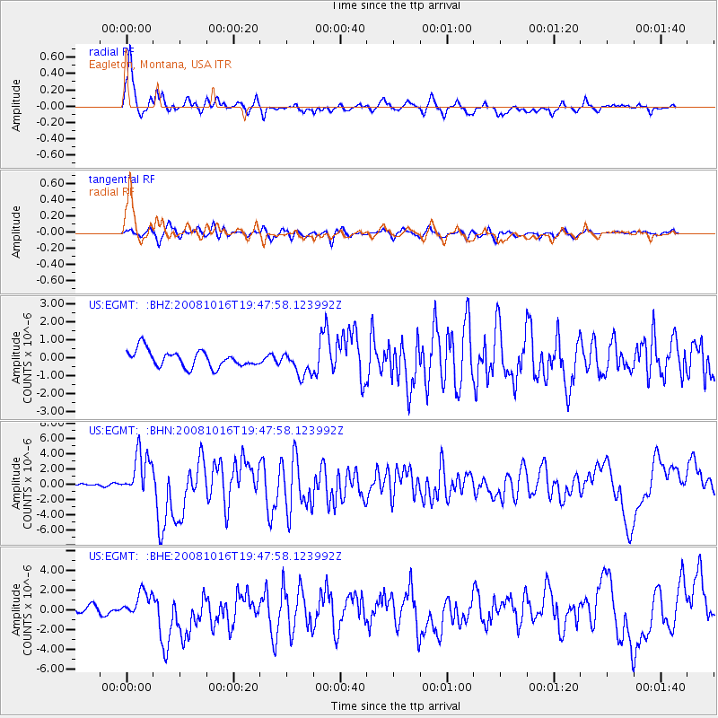
Earthquake location: Near Coast Of Chiapas, Mexico
Earthquake latitude/longitude: 14.4/-92.4
Earthquake time(UTC): 2008/10/16 (290) 19:41:25 GMT
Earthquake Depth: 24 km
Earthquake Magnitude: 6.1 MB, 6.6 MS, 6.7 MW, 6.6 MW
Earthquake Catalog/Contributor: WHDF/NEIC
Network: US United States National Seismic Network
Station: EGMT Eagleton, Montana, USA
Lat/Lon: 48.02 N/109.75 W
Elevation: 1055 m
Distance: 36.5 deg
Az: 340.274 deg
Baz: 150.847 deg
Ray Param: 0.07662563
Estimated Moho Depth: 41.75 km
Estimated Crust Vp/Vs: 1.83
Assumed Crust Vp: 6.438 km/s
Estimated Crust Vs: 3.518 km/s
Estimated Crust Poisson's Ratio: 0.29
Radial Match: 91.84876 %
Radial Bump: 339
Transverse Match: 84.599434 %
Transverse Bump: 400
SOD ConfigId: 2556
Insert Time: 2010-03-05 07:25:49.768 +0000
GWidth: 2.5
Max Bumps: 400
Tol: 0.001

Signal To Noise

ChannelStoNSTALTA
US:EGMT: :BHN:20081016T19:47:58.123992Z14.826682.9392459E-61.9824033E-7
US:EGMT: :BHE:20081016T19:47:58.123992Z2.0245551.2431553E-66.140388E-7
US:EGMT: :BHZ:20081016T19:47:58.123992Z1.50421616.895169E-74.5838956E-7
Arrivals
Ps5.8 SECOND
PpPs17 SECOND
PsPs/PpSs23 SECOND