You are here: Home > Network List > TA - USArray Transportable Network (new EarthScope stations) Stations List
> Station D25K Kavik River, AK, USA > Earthquake Result Viewer
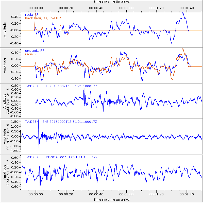
D25K Kavik River, AK, USA - Earthquake Result Viewer
*The percent match for this event was below the threshold and hence no stack was calculated.
| Earthquake location: |
Luzon, Philippines |
| Earthquake latitude/longitude: |
16.4/119.8 |
| Earthquake time(UTC): |
2016/10/02 (276) 13:40:04 GMT |
| Earthquake Depth: |
10 km |
| Earthquake Magnitude: |
5.7 MB |
| Earthquake Catalog/Contributor: |
NEIC PDE/NEIC COMCAT |
|
| Network: |
TA USArray Transportable Network (new EarthScope stations) |
| Station: |
D25K Kavik River, AK, USA |
| Lat/Lon: |
69.32 N/146.38 W |
| Elevation: |
770 m |
|
| Distance: |
76.2 deg |
| Az: |
21.406 deg |
| Baz: |
279.495 deg |
| Ray Param: |
$rayparam |
*The percent match for this event was below the threshold and hence was not used in the summary stack. |
|
| Radial Match: |
42.063644 % |
| Radial Bump: |
400 |
| Transverse Match: |
49.783184 % |
| Transverse Bump: |
400 |
| SOD ConfigId: |
11737051 |
| Insert Time: |
2019-04-25 16:30:18.261 +0000 |
| GWidth: |
2.5 |
| Max Bumps: |
400 |
| Tol: |
0.001 |
|
Signal To Noise
| Channel | StoN | STA | LTA |
| TA:D25K: :BHZ:20161002T13:51:21.100017Z | 3.5266132 | 5.0839475E-7 | 1.4415949E-7 |
| TA:D25K: :BHN:20161002T13:51:21.100017Z | 1.427808 | 2.9790897E-7 | 2.0864776E-7 |
| TA:D25K: :BHE:20161002T13:51:21.100017Z | 2.8355281 | 2.891795E-7 | 1.01984355E-7 |
| Arrivals |
| Ps | |
| PpPs | |
| PsPs/PpSs | |


