You are here: Home > Network List > TA - USArray Transportable Network (new EarthScope stations) Stations List
> Station O18K Koktuh Hills, AK, USA > Earthquake Result Viewer
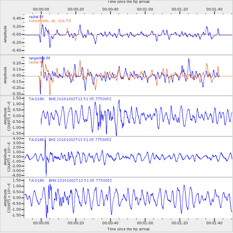
O18K Koktuh Hills, AK, USA - Earthquake Result Viewer
*The percent match for this event was below the threshold and hence no stack was calculated.
| Earthquake location: |
Luzon, Philippines |
| Earthquake latitude/longitude: |
16.4/119.8 |
| Earthquake time(UTC): |
2016/10/02 (276) 13:40:04 GMT |
| Earthquake Depth: |
10 km |
| Earthquake Magnitude: |
5.7 MB |
| Earthquake Catalog/Contributor: |
NEIC PDE/NEIC COMCAT |
|
| Network: |
TA USArray Transportable Network (new EarthScope stations) |
| Station: |
O18K Koktuh Hills, AK, USA |
| Lat/Lon: |
59.85 N/155.21 W |
| Elevation: |
544 m |
|
| Distance: |
73.5 deg |
| Az: |
31.63 deg |
| Baz: |
274.179 deg |
| Ray Param: |
$rayparam |
*The percent match for this event was below the threshold and hence was not used in the summary stack. |
|
| Radial Match: |
41.05874 % |
| Radial Bump: |
400 |
| Transverse Match: |
50.15688 % |
| Transverse Bump: |
400 |
| SOD ConfigId: |
11737051 |
| Insert Time: |
2019-04-25 16:31:06.381 +0000 |
| GWidth: |
2.5 |
| Max Bumps: |
400 |
| Tol: |
0.001 |
|
Signal To Noise
| Channel | StoN | STA | LTA |
| TA:O18K: :BHZ:20161002T13:51:05.775005Z | 3.2553306 | 1.4101537E-6 | 4.3318292E-7 |
| TA:O18K: :BHN:20161002T13:51:05.775005Z | 1.2051787 | 6.877836E-7 | 5.7069013E-7 |
| TA:O18K: :BHE:20161002T13:51:05.775005Z | 1.6471795 | 7.956075E-7 | 4.83012E-7 |
| Arrivals |
| Ps | |
| PpPs | |
| PsPs/PpSs | |


