You are here: Home > Network List > US - United States National Seismic Network Stations List
> Station EGMT Eagleton, Montana, USA > Earthquake Result Viewer
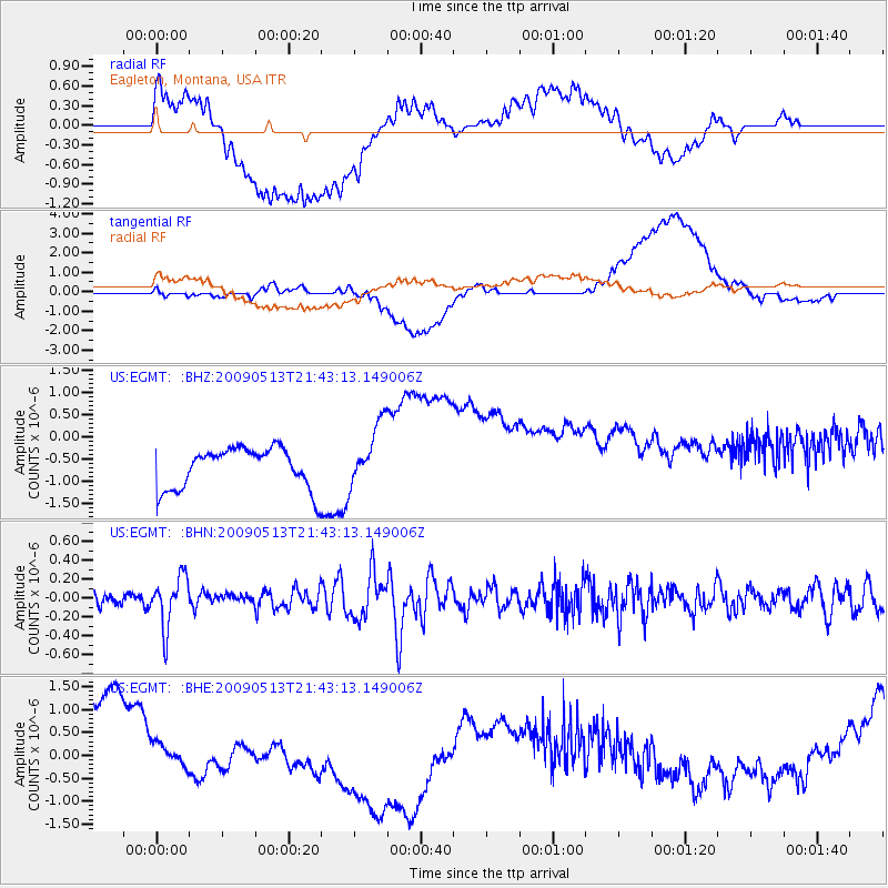
EGMT Eagleton, Montana, USA - Earthquake Result Viewer
*The percent match for this event was below the threshold and hence no stack was calculated.
| Earthquake location: |
Tonga Islands |
| Earthquake latitude/longitude: |
-15.8/-173.5 |
| Earthquake time(UTC): |
2009/05/13 (133) 21:31:17 GMT |
| Earthquake Depth: |
85 km |
| Earthquake Magnitude: |
5.8 MW, 5.3 MB, 5.8 MW |
| Earthquake Catalog/Contributor: |
WHDF/NEIC |
|
| Network: |
US United States National Seismic Network |
| Station: |
EGMT Eagleton, Montana, USA |
| Lat/Lon: |
48.02 N/109.75 W |
| Elevation: |
1055 m |
|
| Distance: |
85.1 deg |
| Az: |
37.174 deg |
| Baz: |
240.081 deg |
| Ray Param: |
$rayparam |
*The percent match for this event was below the threshold and hence was not used in the summary stack. |
|
| Radial Match: |
30.336246 % |
| Radial Bump: |
400 |
| Transverse Match: |
29.909807 % |
| Transverse Bump: |
400 |
| SOD ConfigId: |
2760 |
| Insert Time: |
2010-03-05 07:26:54.093 +0000 |
| GWidth: |
2.5 |
| Max Bumps: |
400 |
| Tol: |
0.001 |
|
Signal To Noise
| Channel | StoN | STA | LTA |
| US:EGMT: :BHN:20090513T21:43:13.149006Z | 3.697644 | 2.6566426E-7 | 7.18469E-8 |
| US:EGMT: :BHE:20090513T21:43:13.149006Z | 0.7905834 | 4.8904036E-7 | 6.185816E-7 |
| US:EGMT: :BHZ:20090513T21:43:13.149006Z | 1.5671462 | 7.117417E-7 | 4.541642E-7 |
| Arrivals |
| Ps | |
| PpPs | |
| PsPs/PpSs | |


