You are here: Home > Network List > US - United States National Seismic Network Stations List
> Station EGMT Eagleton, Montana, USA > Earthquake Result Viewer
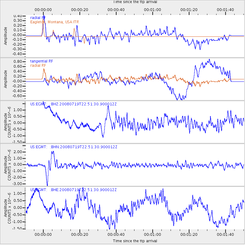
EGMT Eagleton, Montana, USA - Earthquake Result Viewer
*The percent match for this event was below the threshold and hence no stack was calculated.
| Earthquake location: |
Fiji Islands Region |
| Earthquake latitude/longitude: |
-17.3/-177.3 |
| Earthquake time(UTC): |
2008/07/19 (201) 22:39:52 GMT |
| Earthquake Depth: |
391 km |
| Earthquake Magnitude: |
5.9 MB, 6.4 MW, 6.4 MW |
| Earthquake Catalog/Contributor: |
WHDF/NEIC |
|
| Network: |
US United States National Seismic Network |
| Station: |
EGMT Eagleton, Montana, USA |
| Lat/Lon: |
48.02 N/109.75 W |
| Elevation: |
1055 m |
|
| Distance: |
88.6 deg |
| Az: |
38.364 deg |
| Baz: |
242.016 deg |
| Ray Param: |
$rayparam |
*The percent match for this event was below the threshold and hence was not used in the summary stack. |
|
| Radial Match: |
53.876682 % |
| Radial Bump: |
400 |
| Transverse Match: |
31.703259 % |
| Transverse Bump: |
400 |
| SOD ConfigId: |
2504 |
| Insert Time: |
2010-03-05 07:26:57.976 +0000 |
| GWidth: |
2.5 |
| Max Bumps: |
400 |
| Tol: |
0.001 |
|
Signal To Noise
| Channel | StoN | STA | LTA |
| US:EGMT: :BHN:20080719T22:51:30.900012Z | 15.195028 | 1.3210233E-6 | 8.693787E-8 |
| US:EGMT: :BHE:20080719T22:51:30.900012Z | 0.50387067 | 7.0479905E-7 | 1.3987698E-6 |
| US:EGMT: :BHZ:20080719T22:51:30.900012Z | 1.3291048 | 7.3190637E-7 | 5.506762E-7 |
| Arrivals |
| Ps | |
| PpPs | |
| PsPs/PpSs | |


