You are here: Home > Network List > US - United States National Seismic Network Stations List
> Station EGMT Eagleton, Montana, USA > Earthquake Result Viewer
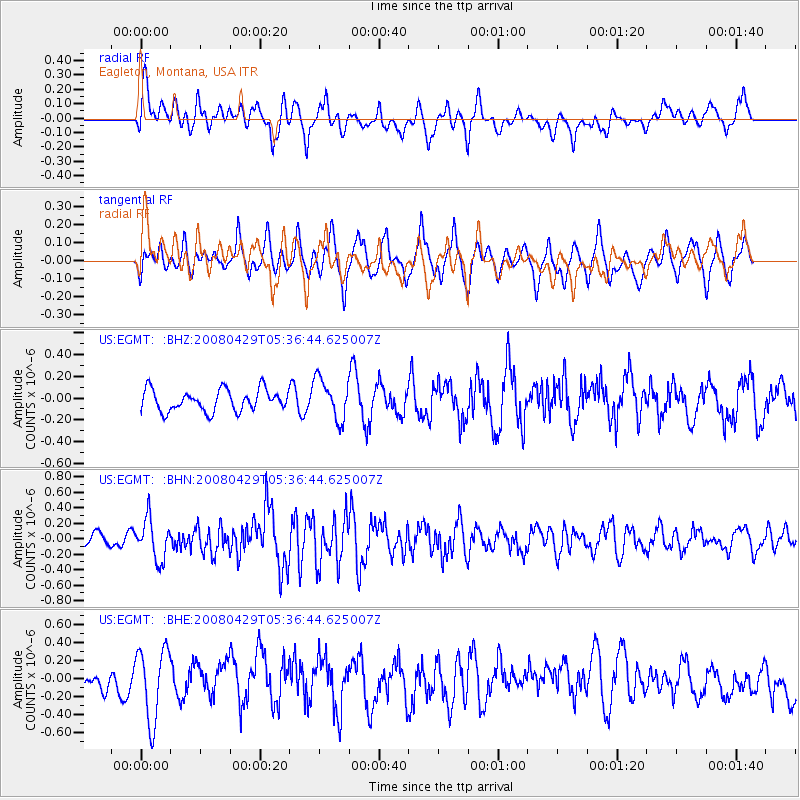
EGMT Eagleton, Montana, USA - Earthquake Result Viewer
*The percent match for this event was below the threshold and hence no stack was calculated.
| Earthquake location: |
Hokkaido, Japan Region |
| Earthquake latitude/longitude: |
41.5/142.0 |
| Earthquake time(UTC): |
2008/04/29 (120) 05:26:04 GMT |
| Earthquake Depth: |
47 km |
| Earthquake Magnitude: |
5.5 MB, 5.2 MS, 5.8 MW, 5.8 MW |
| Earthquake Catalog/Contributor: |
WHDF/NEIC |
|
| Network: |
US United States National Seismic Network |
| Station: |
EGMT Eagleton, Montana, USA |
| Lat/Lon: |
48.02 N/109.75 W |
| Elevation: |
1055 m |
|
| Distance: |
70.7 deg |
| Az: |
42.514 deg |
| Baz: |
310.824 deg |
| Ray Param: |
$rayparam |
*The percent match for this event was below the threshold and hence was not used in the summary stack. |
|
| Radial Match: |
52.78461 % |
| Radial Bump: |
400 |
| Transverse Match: |
56.04359 % |
| Transverse Bump: |
400 |
| SOD ConfigId: |
2504 |
| Insert Time: |
2010-03-05 07:27:02.097 +0000 |
| GWidth: |
2.5 |
| Max Bumps: |
400 |
| Tol: |
0.001 |
|
Signal To Noise
| Channel | StoN | STA | LTA |
| US:EGMT: :BHN:20080429T05:36:44.625007Z | 1.8934265 | 2.5936993E-7 | 1.3698443E-7 |
| US:EGMT: :BHE:20080429T05:36:44.625007Z | 1.8538642 | 4.0217654E-7 | 2.169396E-7 |
| US:EGMT: :BHZ:20080429T05:36:44.625007Z | 1.8939778 | 1.8679034E-7 | 9.86233E-8 |
| Arrivals |
| Ps | |
| PpPs | |
| PsPs/PpSs | |


