You are here: Home > Network List > IU - Global Seismograph Network (GSN - IRIS/USGS) Stations List
> Station XMAS Kiritimati Island, Republic of Kiribati > Earthquake Result Viewer
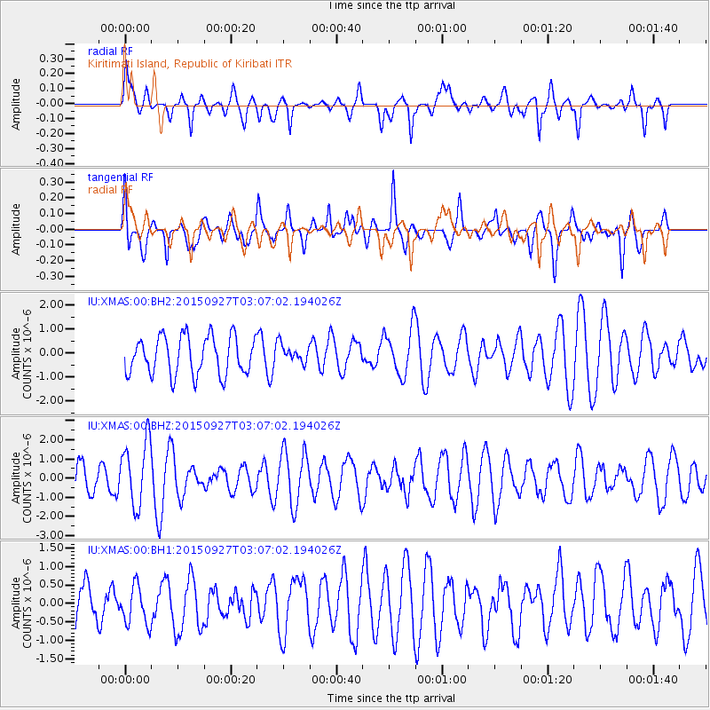
XMAS Kiritimati Island, Republic of Kiribati - Earthquake Result Viewer
*The percent match for this event was below the threshold and hence no stack was calculated.
| Earthquake location: |
Banda Sea |
| Earthquake latitude/longitude: |
-7.2/129.7 |
| Earthquake time(UTC): |
2015/09/27 (270) 02:56:13 GMT |
| Earthquake Depth: |
110 km |
| Earthquake Magnitude: |
5.6 MB |
| Earthquake Catalog/Contributor: |
NEIC PDE/NEIC COMCAT |
|
| Network: |
IU Global Seismograph Network (GSN - IRIS/USGS) |
| Station: |
XMAS Kiritimati Island, Republic of Kiribati |
| Lat/Lon: |
2.04 N/157.45 W |
| Elevation: |
20 m |
|
| Distance: |
73.2 deg |
| Az: |
85.682 deg |
| Baz: |
261.864 deg |
| Ray Param: |
$rayparam |
*The percent match for this event was below the threshold and hence was not used in the summary stack. |
|
| Radial Match: |
52.35512 % |
| Radial Bump: |
400 |
| Transverse Match: |
71.43863 % |
| Transverse Bump: |
400 |
| SOD ConfigId: |
1156111 |
| Insert Time: |
2015-10-11 03:49:39.340 +0000 |
| GWidth: |
2.5 |
| Max Bumps: |
400 |
| Tol: |
0.001 |
|
Signal To Noise
| Channel | StoN | STA | LTA |
| IU:XMAS:00:BHZ:20150927T03:07:02.194026Z | 2.4931462 | 1.7099027E-6 | 6.858413E-7 |
| IU:XMAS:00:BH1:20150927T03:07:02.194026Z | 0.66615963 | 5.376447E-7 | 8.07081E-7 |
| IU:XMAS:00:BH2:20150927T03:07:02.194026Z | 0.4530491 | 3.6213999E-7 | 7.993394E-7 |
| Arrivals |
| Ps | |
| PpPs | |
| PsPs/PpSs | |


