You are here: Home > Network List > AV - Alaska Volcano Observatory Stations List
> Station SPCR Ckakachatna River, Mount Spurr, Alaska > Earthquake Result Viewer
SPCR Ckakachatna River, Mount Spurr, Alaska - Earthquake Result Viewer
*The percent match for this event was below the threshold and hence no stack was calculated.
| Earthquake location: |
Bonin Islands, Japan Region |
| Earthquake latitude/longitude: |
27.9/142.0 |
| Earthquake time(UTC): |
2016/10/04 (278) 14:00:46 GMT |
| Earthquake Depth: |
30 km |
| Earthquake Magnitude: |
5.6 MO |
| Earthquake Catalog/Contributor: |
NEIC PDE/NEIC ALERT |
|
| Network: |
AV Alaska Volcano Observatory |
| Station: |
SPCR Ckakachatna River, Mount Spurr, Alaska |
| Lat/Lon: |
61.20 N/152.21 W |
| Elevation: |
984 m |
|
| Distance: |
54.4 deg |
| Az: |
32.926 deg |
| Baz: |
263.518 deg |
| Ray Param: |
$rayparam |
*The percent match for this event was below the threshold and hence was not used in the summary stack. |
|
| Radial Match: |
65.27855 % |
| Radial Bump: |
400 |
| Transverse Match: |
68.92726 % |
| Transverse Bump: |
400 |
| SOD ConfigId: |
11737051 |
| Insert Time: |
2019-04-25 16:35:00.079 +0000 |
| GWidth: |
2.5 |
| Max Bumps: |
400 |
| Tol: |
0.001 |
|
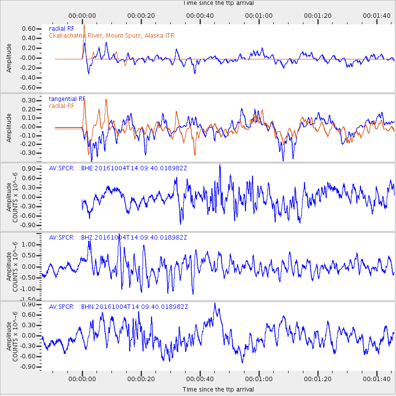
Signal To Noise
| Channel | StoN | STA | LTA |
| AV:SPCR: :BHZ:20161004T14:09:40.018982Z | 3.2214644 | 5.81003E-7 | 1.8035368E-7 |
| AV:SPCR: :BHN:20161004T14:09:40.018982Z | 0.8117817 | 2.3163561E-7 | 2.8534225E-7 |
| AV:SPCR: :BHE:20161004T14:09:40.018982Z | 1.4655842 | 3.3689525E-7 | 2.2987099E-7 |
| Arrivals |
| Ps | |
| PpPs | |
| PsPs/PpSs | |


