You are here: Home > Network List > US - United States National Seismic Network Stations List
> Station EGMT Eagleton, Montana, USA > Earthquake Result Viewer
EGMT Eagleton, Montana, USA - Earthquake Result Viewer
*The percent match for this event was below the threshold and hence no stack was calculated.
| Earthquake location: |
Kuril Islands |
| Earthquake latitude/longitude: |
46.5/153.3 |
| Earthquake time(UTC): |
2008/06/23 (175) 12:32:12 GMT |
| Earthquake Depth: |
10 km |
| Earthquake Magnitude: |
5.6 MB, 5.2 MS, 5.6 MW, 5.6 MW |
| Earthquake Catalog/Contributor: |
WHDF/NEIC |
|
| Network: |
US United States National Seismic Network |
| Station: |
EGMT Eagleton, Montana, USA |
| Lat/Lon: |
48.02 N/109.75 W |
| Elevation: |
1055 m |
|
| Distance: |
61.4 deg |
| Az: |
49.399 deg |
| Baz: |
308.596 deg |
| Ray Param: |
$rayparam |
*The percent match for this event was below the threshold and hence was not used in the summary stack. |
|
| Radial Match: |
64.62918 % |
| Radial Bump: |
400 |
| Transverse Match: |
66.65369 % |
| Transverse Bump: |
400 |
| SOD ConfigId: |
2504 |
| Insert Time: |
2010-03-05 07:27:14.307 +0000 |
| GWidth: |
2.5 |
| Max Bumps: |
400 |
| Tol: |
0.001 |
|
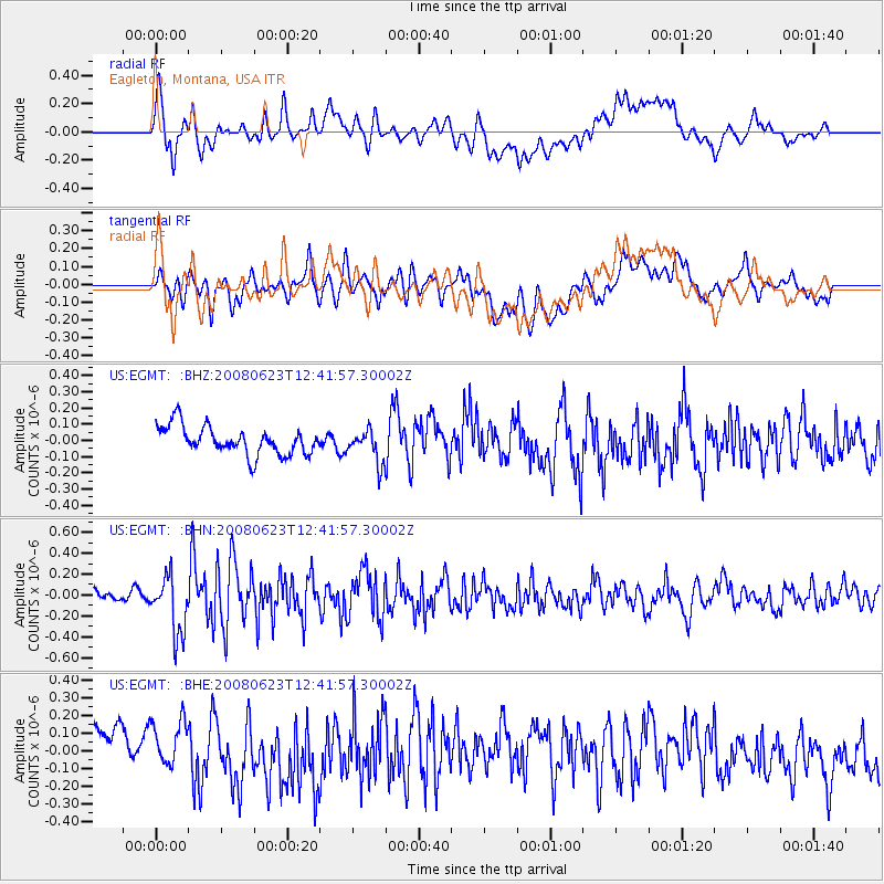
Signal To Noise
| Channel | StoN | STA | LTA |
| US:EGMT: :BHN:20080623T12:41:57.30002Z | 5.9759564 | 2.733407E-7 | 4.5740073E-8 |
| US:EGMT: :BHE:20080623T12:41:57.30002Z | 0.9554426 | 1.561975E-7 | 1.6348181E-7 |
| US:EGMT: :BHZ:20080623T12:41:57.30002Z | 1.1518458 | 9.969039E-8 | 8.6548376E-8 |
| Arrivals |
| Ps | |
| PpPs | |
| PsPs/PpSs | |


