You are here: Home > Network List > CI - Caltech Regional Seismic Network Stations List
> Station MPM Manuel Prospect Mine, California, USA > Earthquake Result Viewer
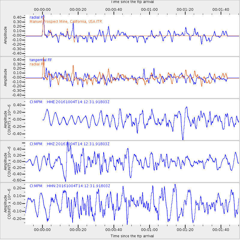
MPM Manuel Prospect Mine, California, USA - Earthquake Result Viewer
*The percent match for this event was below the threshold and hence no stack was calculated.
| Earthquake location: |
Bonin Islands, Japan Region |
| Earthquake latitude/longitude: |
27.9/142.0 |
| Earthquake time(UTC): |
2016/10/04 (278) 14:00:46 GMT |
| Earthquake Depth: |
30 km |
| Earthquake Magnitude: |
5.6 MO |
| Earthquake Catalog/Contributor: |
NEIC PDE/NEIC ALERT |
|
| Network: |
CI Caltech Regional Seismic Network |
| Station: |
MPM Manuel Prospect Mine, California, USA |
| Lat/Lon: |
36.06 N/117.49 W |
| Elevation: |
185 m |
|
| Distance: |
81.9 deg |
| Az: |
53.578 deg |
| Baz: |
298.477 deg |
| Ray Param: |
$rayparam |
*The percent match for this event was below the threshold and hence was not used in the summary stack. |
|
| Radial Match: |
63.7998 % |
| Radial Bump: |
400 |
| Transverse Match: |
57.999912 % |
| Transverse Bump: |
400 |
| SOD ConfigId: |
11737051 |
| Insert Time: |
2019-04-25 16:35:50.466 +0000 |
| GWidth: |
2.5 |
| Max Bumps: |
400 |
| Tol: |
0.001 |
|
Signal To Noise
| Channel | StoN | STA | LTA |
| CI:MPM: :HHZ:20161004T14:12:31.91803Z | 1.6483736 | 1.4224636E-7 | 8.6294975E-8 |
| CI:MPM: :HHN:20161004T14:12:31.91803Z | 1.597403 | 1.515165E-7 | 9.485177E-8 |
| CI:MPM: :HHE:20161004T14:12:31.91803Z | 1.2432264 | 1.3292576E-7 | 1.0691999E-7 |
| Arrivals |
| Ps | |
| PpPs | |
| PsPs/PpSs | |


