You are here: Home > Network List > US - United States National Seismic Network Stations List
> Station EGMT Eagleton, Montana, USA > Earthquake Result Viewer
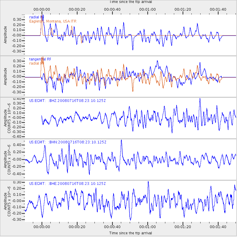
EGMT Eagleton, Montana, USA - Earthquake Result Viewer
*The percent match for this event was below the threshold and hence no stack was calculated.
| Earthquake location: |
Samoa Islands Region |
| Earthquake latitude/longitude: |
-16.6/-173.0 |
| Earthquake time(UTC): |
2008/07/16 (198) 08:11:04 GMT |
| Earthquake Depth: |
10 km |
| Earthquake Magnitude: |
5.5 MB, 5.4 MS, 5.7 MW, 5.7 MW |
| Earthquake Catalog/Contributor: |
WHDF/NEIC |
|
| Network: |
US United States National Seismic Network |
| Station: |
EGMT Eagleton, Montana, USA |
| Lat/Lon: |
48.02 N/109.75 W |
| Elevation: |
1055 m |
|
| Distance: |
85.4 deg |
| Az: |
36.952 deg |
| Baz: |
239.165 deg |
| Ray Param: |
$rayparam |
*The percent match for this event was below the threshold and hence was not used in the summary stack. |
|
| Radial Match: |
70.05234 % |
| Radial Bump: |
400 |
| Transverse Match: |
46.85132 % |
| Transverse Bump: |
400 |
| SOD ConfigId: |
2504 |
| Insert Time: |
2010-03-05 07:27:17.483 +0000 |
| GWidth: |
2.5 |
| Max Bumps: |
400 |
| Tol: |
0.001 |
|
Signal To Noise
| Channel | StoN | STA | LTA |
| US:EGMT: :BHN:20080716T08:23:10.125Z | 6.152091 | 2.1242307E-7 | 3.4528597E-8 |
| US:EGMT: :BHE:20080716T08:23:10.125Z | 1.5296494 | 1.25271E-7 | 8.1895244E-8 |
| US:EGMT: :BHZ:20080716T08:23:10.125Z | 1.102858 | 6.705805E-8 | 6.080389E-8 |
| Arrivals |
| Ps | |
| PpPs | |
| PsPs/PpSs | |


