You are here: Home > Network List > US - United States National Seismic Network Stations List
> Station EGMT Eagleton, Montana, USA > Earthquake Result Viewer
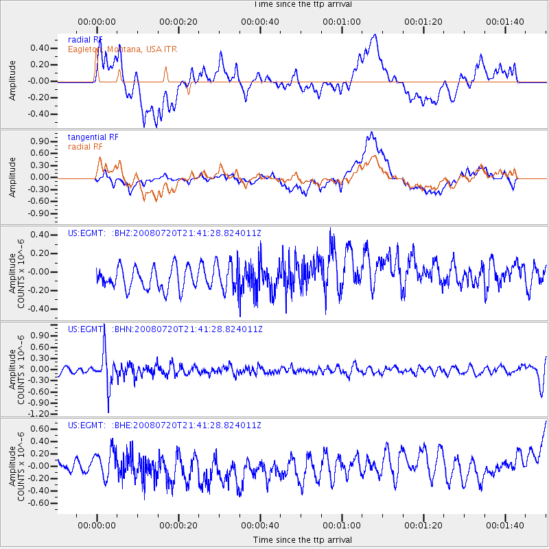
EGMT Eagleton, Montana, USA - Earthquake Result Viewer
*The percent match for this event was below the threshold and hence no stack was calculated.
| Earthquake location: |
Bonin Islands, Japan Region |
| Earthquake latitude/longitude: |
27.8/139.6 |
| Earthquake time(UTC): |
2008/07/20 (202) 21:30:29 GMT |
| Earthquake Depth: |
481 km |
| Earthquake Magnitude: |
5.8 MW, 5.1 MB, 5.8 MW |
| Earthquake Catalog/Contributor: |
WHDF/NEIC |
|
| Network: |
US United States National Seismic Network |
| Station: |
EGMT Eagleton, Montana, USA |
| Lat/Lon: |
48.02 N/109.75 W |
| Elevation: |
1055 m |
|
| Distance: |
82.3 deg |
| Az: |
39.343 deg |
| Baz: |
303.195 deg |
| Ray Param: |
$rayparam |
*The percent match for this event was below the threshold and hence was not used in the summary stack. |
|
| Radial Match: |
23.876644 % |
| Radial Bump: |
400 |
| Transverse Match: |
33.183464 % |
| Transverse Bump: |
400 |
| SOD ConfigId: |
2504 |
| Insert Time: |
2010-03-05 07:27:18.087 +0000 |
| GWidth: |
2.5 |
| Max Bumps: |
400 |
| Tol: |
0.001 |
|
Signal To Noise
| Channel | StoN | STA | LTA |
| US:EGMT: :BHN:20080720T21:41:28.824011Z | 6.0028105 | 4.4483085E-7 | 7.410377E-8 |
| US:EGMT: :BHE:20080720T21:41:28.824011Z | 0.8072769 | 3.8068887E-7 | 4.715716E-7 |
| US:EGMT: :BHZ:20080720T21:41:28.824011Z | 1.3858157 | 1.6076514E-7 | 1.16007584E-7 |
| Arrivals |
| Ps | |
| PpPs | |
| PsPs/PpSs | |


