You are here: Home > Network List > US - United States National Seismic Network Stations List
> Station EGMT Eagleton, Montana, USA > Earthquake Result Viewer
EGMT Eagleton, Montana, USA - Earthquake Result Viewer
*The percent match for this event was below the threshold and hence no stack was calculated.
| Earthquake location: |
Solomon Islands |
| Earthquake latitude/longitude: |
-8.9/159.6 |
| Earthquake time(UTC): |
2008/11/21 (326) 07:05:34 GMT |
| Earthquake Depth: |
118 km |
| Earthquake Magnitude: |
6.0 MB, 6.1 MW, 6.0 MW |
| Earthquake Catalog/Contributor: |
WHDF/NEIC |
|
| Network: |
US United States National Seismic Network |
| Station: |
EGMT Eagleton, Montana, USA |
| Lat/Lon: |
48.02 N/109.75 W |
| Elevation: |
1055 m |
|
| Distance: |
97.0 deg |
| Az: |
42.559 deg |
| Baz: |
264.515 deg |
| Ray Param: |
$rayparam |
*The percent match for this event was below the threshold and hence was not used in the summary stack. |
|
| Radial Match: |
55.461575 % |
| Radial Bump: |
400 |
| Transverse Match: |
42.887665 % |
| Transverse Bump: |
400 |
| SOD ConfigId: |
2658 |
| Insert Time: |
2010-03-05 07:27:28.855 +0000 |
| GWidth: |
2.5 |
| Max Bumps: |
400 |
| Tol: |
0.001 |
|
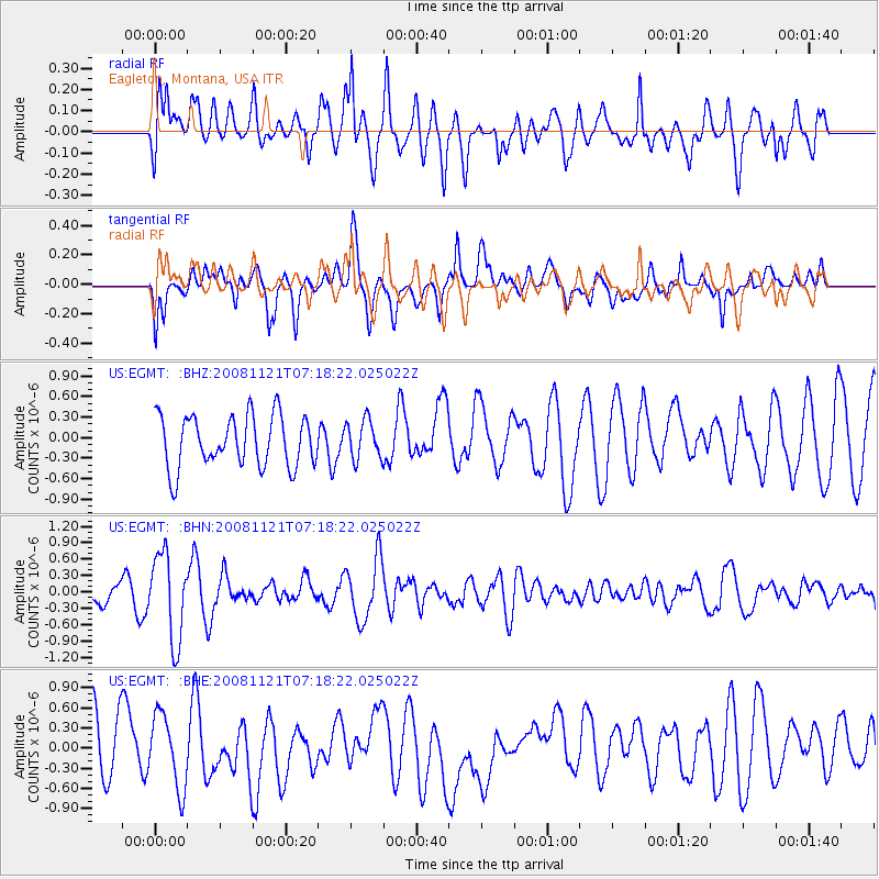
Signal To Noise
| Channel | StoN | STA | LTA |
| US:EGMT: :BHN:20081121T07:18:22.025022Z | 2.8578355 | 7.8917424E-7 | 2.7614405E-7 |
| US:EGMT: :BHE:20081121T07:18:22.025022Z | 1.3216776 | 5.417862E-7 | 4.0992313E-7 |
| US:EGMT: :BHZ:20081121T07:18:22.025022Z | 0.75001246 | 2.8148415E-7 | 3.7530597E-7 |
| Arrivals |
| Ps | |
| PpPs | |
| PsPs/PpSs | |


