You are here: Home > Network List > US - United States National Seismic Network Stations List
> Station EGMT Eagleton, Montana, USA > Earthquake Result Viewer
EGMT Eagleton, Montana, USA - Earthquake Result Viewer
*The percent match for this event was below the threshold and hence no stack was calculated.
| Earthquake location: |
Tonga Islands |
| Earthquake latitude/longitude: |
-21.7/-174.6 |
| Earthquake time(UTC): |
2009/08/13 (225) 11:17:01 GMT |
| Earthquake Depth: |
10 km |
| Earthquake Magnitude: |
5.6 MW, 5.3 MB |
| Earthquake Catalog/Contributor: |
WHDF/NEIC |
|
| Network: |
US United States National Seismic Network |
| Station: |
EGMT Eagleton, Montana, USA |
| Lat/Lon: |
48.02 N/109.75 W |
| Elevation: |
1055 m |
|
| Distance: |
90.4 deg |
| Az: |
37.407 deg |
| Baz: |
237.328 deg |
| Ray Param: |
$rayparam |
*The percent match for this event was below the threshold and hence was not used in the summary stack. |
|
| Radial Match: |
53.100777 % |
| Radial Bump: |
400 |
| Transverse Match: |
31.756485 % |
| Transverse Bump: |
400 |
| SOD ConfigId: |
2622 |
| Insert Time: |
2010-03-05 07:27:31.659 +0000 |
| GWidth: |
2.5 |
| Max Bumps: |
400 |
| Tol: |
0.001 |
|
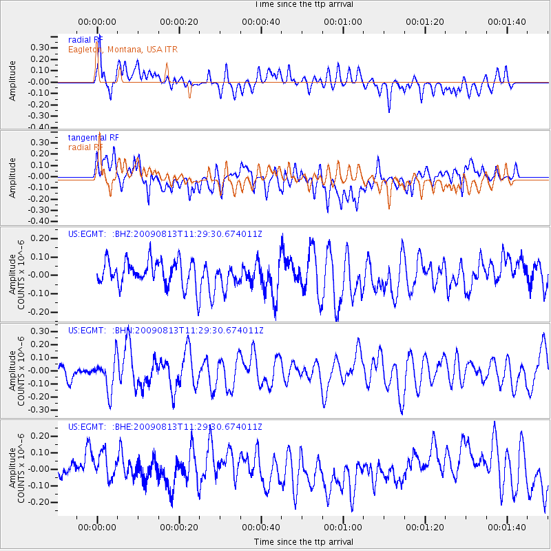
Signal To Noise
| Channel | StoN | STA | LTA |
| US:EGMT: :BHN:20090813T11:29:30.674011Z | 1.7357076 | 1.2757634E-7 | 7.350105E-8 |
| US:EGMT: :BHE:20090813T11:29:30.674011Z | 1.3979765 | 1.5551419E-7 | 1.11242336E-7 |
| US:EGMT: :BHZ:20090813T11:29:30.674011Z | 0.879012 | 6.1435536E-8 | 6.989158E-8 |
| Arrivals |
| Ps | |
| PpPs | |
| PsPs/PpSs | |


