You are here: Home > Network List > US - United States National Seismic Network Stations List
> Station EGMT Eagleton, Montana, USA > Earthquake Result Viewer
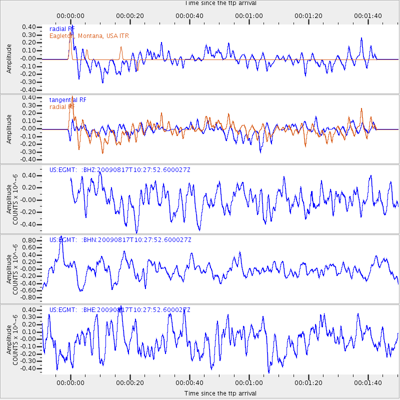
EGMT Eagleton, Montana, USA - Earthquake Result Viewer
*The percent match for this event was below the threshold and hence no stack was calculated.
| Earthquake location: |
Southwestern Ryukyu Isl., Japan |
| Earthquake latitude/longitude: |
23.4/123.7 |
| Earthquake time(UTC): |
2009/08/17 (229) 10:15:05 GMT |
| Earthquake Depth: |
10 km |
| Earthquake Magnitude: |
5.7 MB |
| Earthquake Catalog/Contributor: |
WHDF/NEIC |
|
| Network: |
US United States National Seismic Network |
| Station: |
EGMT Eagleton, Montana, USA |
| Lat/Lon: |
48.02 N/109.75 W |
| Elevation: |
1055 m |
|
| Distance: |
94.3 deg |
| Az: |
32.744 deg |
| Baz: |
312.257 deg |
| Ray Param: |
$rayparam |
*The percent match for this event was below the threshold and hence was not used in the summary stack. |
|
| Radial Match: |
68.99339 % |
| Radial Bump: |
400 |
| Transverse Match: |
51.164696 % |
| Transverse Bump: |
400 |
| SOD ConfigId: |
2622 |
| Insert Time: |
2010-03-05 07:27:34.713 +0000 |
| GWidth: |
2.5 |
| Max Bumps: |
400 |
| Tol: |
0.001 |
|
Signal To Noise
| Channel | StoN | STA | LTA |
| US:EGMT: :BHN:20090817T10:27:52.600027Z | 1.5189795 | 3.363263E-7 | 2.2141595E-7 |
| US:EGMT: :BHE:20090817T10:27:52.600027Z | 1.0008829 | 1.9069341E-7 | 1.9052521E-7 |
| US:EGMT: :BHZ:20090817T10:27:52.600027Z | 0.8267787 | 1.8300751E-7 | 2.2135005E-7 |
| Arrivals |
| Ps | |
| PpPs | |
| PsPs/PpSs | |


