You are here: Home > Network List > TA - USArray Transportable Network (new EarthScope stations) Stations List
> Station F26K Sheenjek River, AK, USA > Earthquake Result Viewer
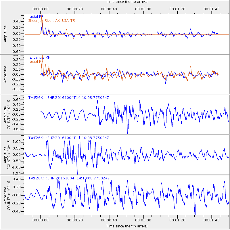
F26K Sheenjek River, AK, USA - Earthquake Result Viewer
*The percent match for this event was below the threshold and hence no stack was calculated.
| Earthquake location: |
Bonin Islands, Japan Region |
| Earthquake latitude/longitude: |
27.9/142.0 |
| Earthquake time(UTC): |
2016/10/04 (278) 14:00:46 GMT |
| Earthquake Depth: |
30 km |
| Earthquake Magnitude: |
5.6 MO |
| Earthquake Catalog/Contributor: |
NEIC PDE/NEIC ALERT |
|
| Network: |
TA USArray Transportable Network (new EarthScope stations) |
| Station: |
F26K Sheenjek River, AK, USA |
| Lat/Lon: |
67.69 N/144.15 W |
| Elevation: |
683 m |
|
| Distance: |
58.4 deg |
| Az: |
25.501 deg |
| Baz: |
266.682 deg |
| Ray Param: |
$rayparam |
*The percent match for this event was below the threshold and hence was not used in the summary stack. |
|
| Radial Match: |
79.86813 % |
| Radial Bump: |
400 |
| Transverse Match: |
67.60207 % |
| Transverse Bump: |
400 |
| SOD ConfigId: |
11737051 |
| Insert Time: |
2019-04-25 16:40:47.364 +0000 |
| GWidth: |
2.5 |
| Max Bumps: |
400 |
| Tol: |
0.001 |
|
Signal To Noise
| Channel | StoN | STA | LTA |
| TA:F26K: :BHZ:20161004T14:10:08.775024Z | 3.9136913 | 4.528224E-7 | 1.1570212E-7 |
| TA:F26K: :BHN:20161004T14:10:08.775024Z | 1.5109261 | 7.283218E-8 | 4.8203663E-8 |
| TA:F26K: :BHE:20161004T14:10:08.775024Z | 1.4627687 | 2.0020482E-7 | 1.3686704E-7 |
| Arrivals |
| Ps | |
| PpPs | |
| PsPs/PpSs | |


