You are here: Home > Network List > US - United States National Seismic Network Stations List
> Station EGMT Eagleton, Montana, USA > Earthquake Result Viewer
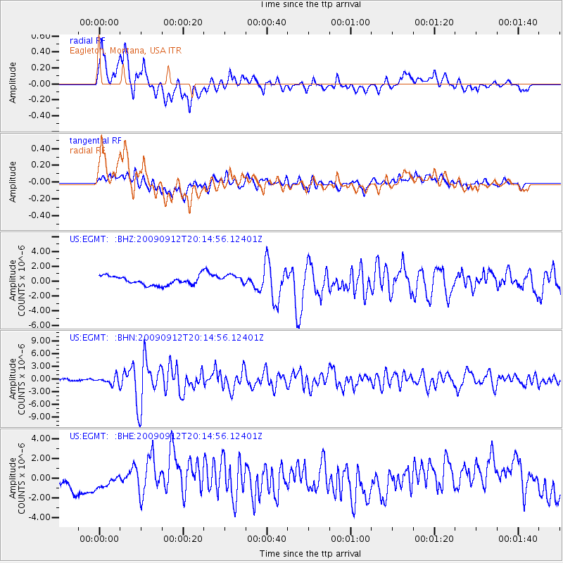
EGMT Eagleton, Montana, USA - Earthquake Result Viewer
*The percent match for this event was below the threshold and hence no stack was calculated.
| Earthquake location: |
Near Coast Of Venezuela |
| Earthquake latitude/longitude: |
10.7/-67.9 |
| Earthquake time(UTC): |
2009/09/12 (255) 20:06:24 GMT |
| Earthquake Depth: |
10 km |
| Earthquake Magnitude: |
6.3 MB, 6.4 MS, 6.3 MW, 6.3 MW |
| Earthquake Catalog/Contributor: |
WHDF/NEIC |
|
| Network: |
US United States National Seismic Network |
| Station: |
EGMT Eagleton, Montana, USA |
| Lat/Lon: |
48.02 N/109.75 W |
| Elevation: |
1055 m |
|
| Distance: |
51.1 deg |
| Az: |
324.861 deg |
| Baz: |
122.577 deg |
| Ray Param: |
$rayparam |
*The percent match for this event was below the threshold and hence was not used in the summary stack. |
|
| Radial Match: |
75.226204 % |
| Radial Bump: |
400 |
| Transverse Match: |
64.453926 % |
| Transverse Bump: |
400 |
| SOD ConfigId: |
2622 |
| Insert Time: |
2010-03-05 07:27:40.216 +0000 |
| GWidth: |
2.5 |
| Max Bumps: |
400 |
| Tol: |
0.001 |
|
Signal To Noise
| Channel | StoN | STA | LTA |
| US:EGMT: :BHN:20090912T20:14:56.12401Z | 5.142977 | 9.448099E-7 | 1.8370876E-7 |
| US:EGMT: :BHE:20090912T20:14:56.12401Z | 0.5275752 | 4.4823906E-7 | 8.496212E-7 |
| US:EGMT: :BHZ:20090912T20:14:56.12401Z | 1.0995336 | 6.4596463E-7 | 5.874897E-7 |
| Arrivals |
| Ps | |
| PpPs | |
| PsPs/PpSs | |


