You are here: Home > Network List > US - United States National Seismic Network Stations List
> Station EGMT Eagleton, Montana, USA > Earthquake Result Viewer
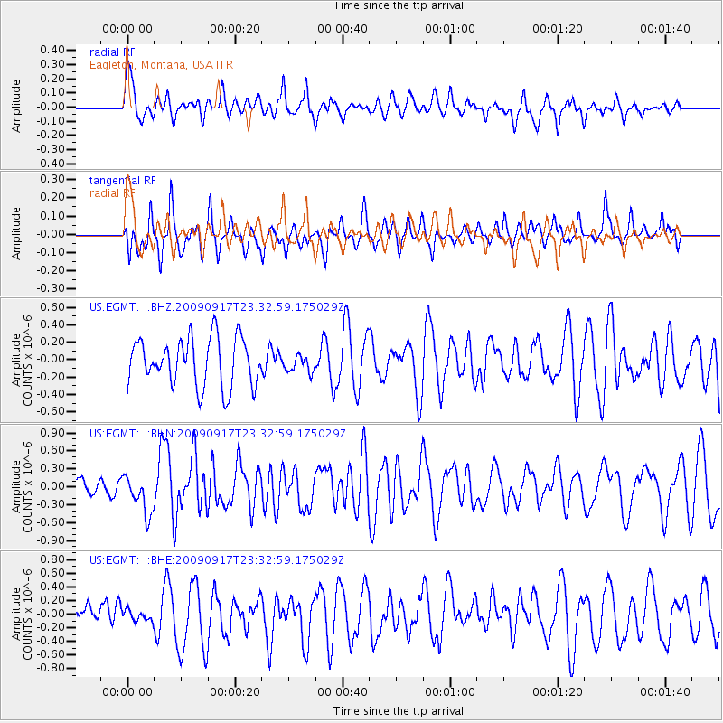
EGMT Eagleton, Montana, USA - Earthquake Result Viewer
*The percent match for this event was below the threshold and hence no stack was calculated.
| Earthquake location: |
Easter Island Region |
| Earthquake latitude/longitude: |
-29.1/-112.3 |
| Earthquake time(UTC): |
2009/09/17 (260) 23:21:38 GMT |
| Earthquake Depth: |
10 km |
| Earthquake Magnitude: |
5.7 MB, 6.0 MS, 6.2 MW, 6.2 MW |
| Earthquake Catalog/Contributor: |
WHDF/NEIC |
|
| Network: |
US United States National Seismic Network |
| Station: |
EGMT Eagleton, Montana, USA |
| Lat/Lon: |
48.02 N/109.75 W |
| Elevation: |
1055 m |
|
| Distance: |
76.8 deg |
| Az: |
1.732 deg |
| Baz: |
182.257 deg |
| Ray Param: |
$rayparam |
*The percent match for this event was below the threshold and hence was not used in the summary stack. |
|
| Radial Match: |
67.96754 % |
| Radial Bump: |
400 |
| Transverse Match: |
62.913925 % |
| Transverse Bump: |
400 |
| SOD ConfigId: |
2622 |
| Insert Time: |
2010-03-05 07:27:41.303 +0000 |
| GWidth: |
2.5 |
| Max Bumps: |
400 |
| Tol: |
0.001 |
|
Signal To Noise
| Channel | StoN | STA | LTA |
| US:EGMT: :BHN:20090917T23:32:59.175029Z | 2.1062393 | 3.277493E-7 | 1.5560876E-7 |
| US:EGMT: :BHE:20090917T23:32:59.175029Z | 0.3941533 | 7.9596056E-8 | 2.0194189E-7 |
| US:EGMT: :BHZ:20090917T23:32:59.175029Z | 0.35143286 | 9.63867E-8 | 2.7426776E-7 |
| Arrivals |
| Ps | |
| PpPs | |
| PsPs/PpSs | |


