You are here: Home > Network List > US - United States National Seismic Network Stations List
> Station EGMT Eagleton, Montana, USA > Earthquake Result Viewer
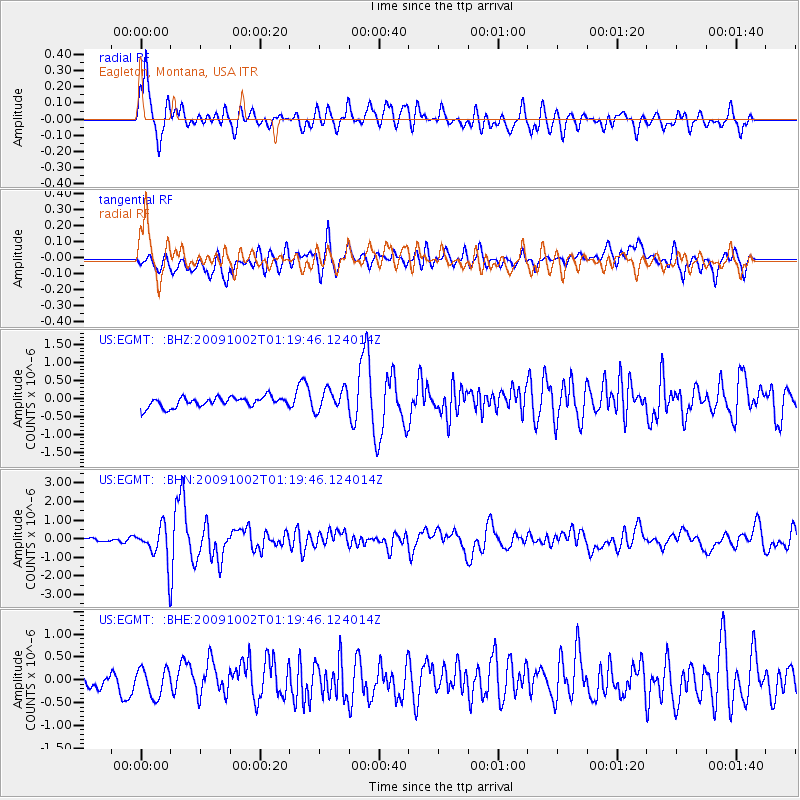
EGMT Eagleton, Montana, USA - Earthquake Result Viewer
*The percent match for this event was below the threshold and hence no stack was calculated.
| Earthquake location: |
Tonga Islands |
| Earthquake latitude/longitude: |
-16.3/-173.5 |
| Earthquake time(UTC): |
2009/10/02 (275) 01:07:39 GMT |
| Earthquake Depth: |
8.0 km |
| Earthquake Magnitude: |
6.1 MB, 6.0 MS, 6.1 MW, 6.1 MW |
| Earthquake Catalog/Contributor: |
WHDF/NEIC |
|
| Network: |
US United States National Seismic Network |
| Station: |
EGMT Eagleton, Montana, USA |
| Lat/Lon: |
48.02 N/109.75 W |
| Elevation: |
1055 m |
|
| Distance: |
85.5 deg |
| Az: |
37.139 deg |
| Baz: |
239.714 deg |
| Ray Param: |
$rayparam |
*The percent match for this event was below the threshold and hence was not used in the summary stack. |
|
| Radial Match: |
79.48338 % |
| Radial Bump: |
400 |
| Transverse Match: |
64.96501 % |
| Transverse Bump: |
400 |
| SOD ConfigId: |
2622 |
| Insert Time: |
2010-03-05 07:27:44.024 +0000 |
| GWidth: |
2.5 |
| Max Bumps: |
400 |
| Tol: |
0.001 |
|
Signal To Noise
| Channel | StoN | STA | LTA |
| US:EGMT: :BHN:20091002T01:19:46.124014Z | 8.567755 | 9.633961E-7 | 1.12444404E-7 |
| US:EGMT: :BHE:20091002T01:19:46.124014Z | 1.0576639 | 3.0173808E-7 | 2.852873E-7 |
| US:EGMT: :BHZ:20091002T01:19:46.124014Z | 2.2029407 | 3.1144776E-7 | 1.4137818E-7 |
| Arrivals |
| Ps | |
| PpPs | |
| PsPs/PpSs | |


