You are here: Home > Network List > US - United States National Seismic Network Stations List
> Station EGMT Eagleton, Montana, USA > Earthquake Result Viewer
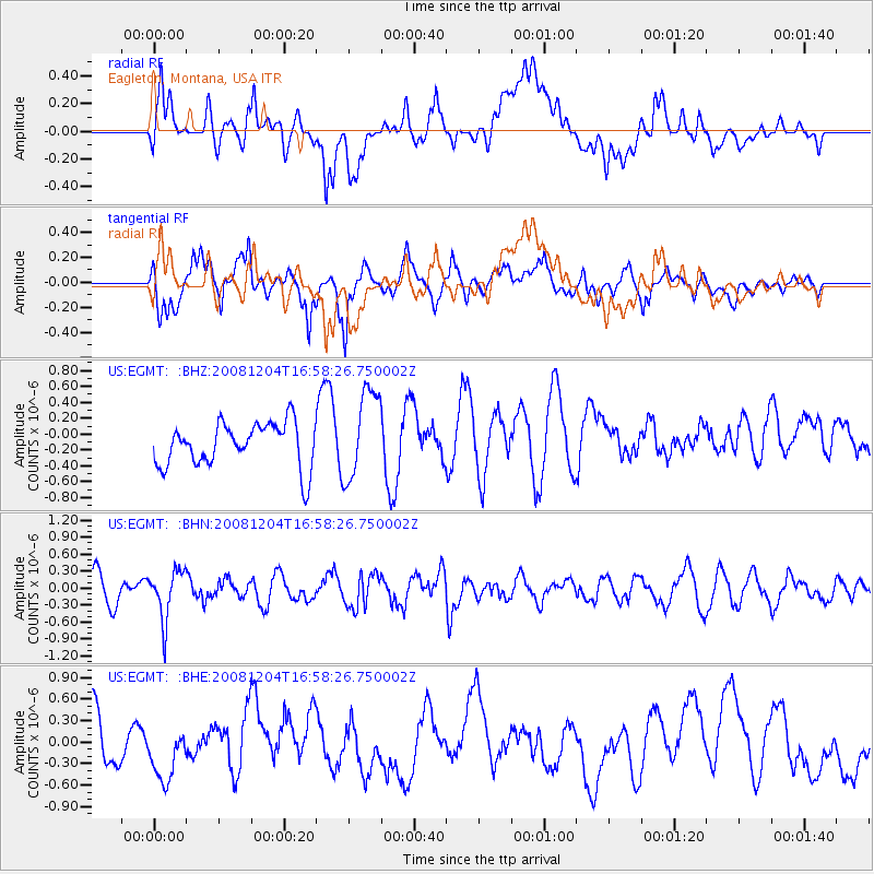
EGMT Eagleton, Montana, USA - Earthquake Result Viewer
*The percent match for this event was below the threshold and hence no stack was calculated.
| Earthquake location: |
Chile-Bolivia Border Region |
| Earthquake latitude/longitude: |
-21.4/-68.3 |
| Earthquake time(UTC): |
2008/12/04 (339) 16:47:09 GMT |
| Earthquake Depth: |
115 km |
| Earthquake Magnitude: |
5.5 MB, 5.5 MW, 5.5 MW |
| Earthquake Catalog/Contributor: |
WHDF/NEIC |
|
| Network: |
US United States National Seismic Network |
| Station: |
EGMT Eagleton, Montana, USA |
| Lat/Lon: |
48.02 N/109.75 W |
| Elevation: |
1055 m |
|
| Distance: |
78.5 deg |
| Az: |
333.019 deg |
| Baz: |
140.96 deg |
| Ray Param: |
$rayparam |
*The percent match for this event was below the threshold and hence was not used in the summary stack. |
|
| Radial Match: |
39.271805 % |
| Radial Bump: |
400 |
| Transverse Match: |
62.16135 % |
| Transverse Bump: |
400 |
| SOD ConfigId: |
2658 |
| Insert Time: |
2010-03-05 07:28:06.944 +0000 |
| GWidth: |
2.5 |
| Max Bumps: |
400 |
| Tol: |
0.001 |
|
Signal To Noise
| Channel | StoN | STA | LTA |
| US:EGMT: :BHN:20081204T16:58:26.750002Z | 1.9052529 | 4.362848E-7 | 2.2899049E-7 |
| US:EGMT: :BHE:20081204T16:58:26.750002Z | 1.0883687 | 4.7264666E-7 | 4.3427076E-7 |
| US:EGMT: :BHZ:20081204T16:58:26.750002Z | 2.0547369 | 5.640218E-7 | 2.744983E-7 |
| Arrivals |
| Ps | |
| PpPs | |
| PsPs/PpSs | |


