You are here: Home > Network List > TA - USArray Transportable Network (new EarthScope stations) Stations List
> Station R32K Eaglecrest, AK, USA > Earthquake Result Viewer
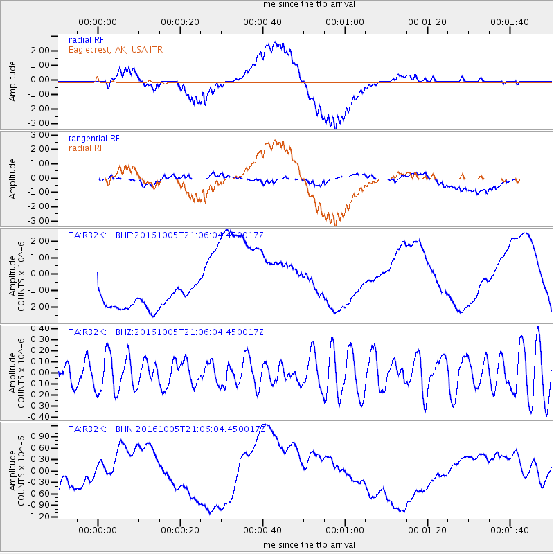
R32K Eaglecrest, AK, USA - Earthquake Result Viewer
*The percent match for this event was below the threshold and hence no stack was calculated.
| Earthquake location: |
Central Mid-Atlantic Ridge |
| Earthquake latitude/longitude: |
7.1/-34.3 |
| Earthquake time(UTC): |
2016/10/05 (279) 20:53:39 GMT |
| Earthquake Depth: |
10 km |
| Earthquake Magnitude: |
5.5 mwb |
| Earthquake Catalog/Contributor: |
NEIC PDE/ |
|
| Network: |
TA USArray Transportable Network (new EarthScope stations) |
| Station: |
R32K Eaglecrest, AK, USA |
| Lat/Lon: |
58.27 N/134.52 W |
| Elevation: |
386 m |
|
| Distance: |
89.3 deg |
| Az: |
328.662 deg |
| Baz: |
77.613 deg |
| Ray Param: |
$rayparam |
*The percent match for this event was below the threshold and hence was not used in the summary stack. |
|
| Radial Match: |
12.315806 % |
| Radial Bump: |
400 |
| Transverse Match: |
14.254349 % |
| Transverse Bump: |
400 |
| SOD ConfigId: |
11737051 |
| Insert Time: |
2019-04-25 16:52:39.526 +0000 |
| GWidth: |
2.5 |
| Max Bumps: |
400 |
| Tol: |
0.001 |
|
Signal To Noise
| Channel | StoN | STA | LTA |
| TA:R32K: :BHZ:20161005T21:06:04.450017Z | 1.3179017 | 1.8413647E-7 | 1.3971942E-7 |
| TA:R32K: :BHN:20161005T21:06:04.450017Z | 2.209203 | 4.2059455E-7 | 1.9038293E-7 |
| TA:R32K: :BHE:20161005T21:06:04.450017Z | 7.3039474 | 3.9930774E-6 | 5.4670124E-7 |
| Arrivals |
| Ps | |
| PpPs | |
| PsPs/PpSs | |


