You are here: Home > Network List > US - United States National Seismic Network Stations List
> Station EGMT Eagleton, Montana, USA > Earthquake Result Viewer
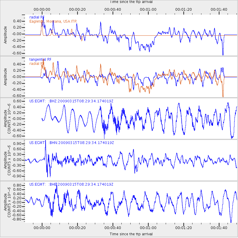
EGMT Eagleton, Montana, USA - Earthquake Result Viewer
*The percent match for this event was below the threshold and hence no stack was calculated.
| Earthquake location: |
Central Peru |
| Earthquake latitude/longitude: |
-14.5/-70.4 |
| Earthquake time(UTC): |
2009/03/15 (074) 08:19:05 GMT |
| Earthquake Depth: |
190 km |
| Earthquake Magnitude: |
5.7 MW, 5.1 MB, 5.6 MW |
| Earthquake Catalog/Contributor: |
WHDF/NEIC |
|
| Network: |
US United States National Seismic Network |
| Station: |
EGMT Eagleton, Montana, USA |
| Lat/Lon: |
48.02 N/109.75 W |
| Elevation: |
1055 m |
|
| Distance: |
71.4 deg |
| Az: |
333.292 deg |
| Baz: |
139.563 deg |
| Ray Param: |
$rayparam |
*The percent match for this event was below the threshold and hence was not used in the summary stack. |
|
| Radial Match: |
67.72731 % |
| Radial Bump: |
400 |
| Transverse Match: |
55.448906 % |
| Transverse Bump: |
372 |
| SOD ConfigId: |
2658 |
| Insert Time: |
2010-03-05 07:28:18.769 +0000 |
| GWidth: |
2.5 |
| Max Bumps: |
400 |
| Tol: |
0.001 |
|
Signal To Noise
| Channel | StoN | STA | LTA |
| US:EGMT: :BHN:20090315T08:29:34.174019Z | 3.1237457 | 3.9619E-7 | 1.268317E-7 |
| US:EGMT: :BHE:20090315T08:29:34.174019Z | 1.2715293 | 2.666569E-7 | 2.0971353E-7 |
| US:EGMT: :BHZ:20090315T08:29:34.174019Z | 1.2279904 | 2.9276416E-7 | 2.3840917E-7 |
| Arrivals |
| Ps | |
| PpPs | |
| PsPs/PpSs | |


