You are here: Home > Network List > US - United States National Seismic Network Stations List
> Station EGMT Eagleton, Montana, USA > Earthquake Result Viewer
EGMT Eagleton, Montana, USA - Earthquake Result Viewer
*The percent match for this event was below the threshold and hence no stack was calculated.
| Earthquake location: |
Central Mid-Atlantic Ridge |
| Earthquake latitude/longitude: |
7.1/-34.3 |
| Earthquake time(UTC): |
2016/10/05 (279) 20:53:39 GMT |
| Earthquake Depth: |
10 km |
| Earthquake Magnitude: |
5.5 mwb |
| Earthquake Catalog/Contributor: |
NEIC PDE/ |
|
| Network: |
US United States National Seismic Network |
| Station: |
EGMT Eagleton, Montana, USA |
| Lat/Lon: |
48.02 N/109.75 W |
| Elevation: |
1055 m |
|
| Distance: |
75.0 deg |
| Az: |
317.724 deg |
| Baz: |
96.061 deg |
| Ray Param: |
$rayparam |
*The percent match for this event was below the threshold and hence was not used in the summary stack. |
|
| Radial Match: |
47.02577 % |
| Radial Bump: |
400 |
| Transverse Match: |
65.444244 % |
| Transverse Bump: |
400 |
| SOD ConfigId: |
11737051 |
| Insert Time: |
2019-04-25 16:53:25.350 +0000 |
| GWidth: |
2.5 |
| Max Bumps: |
400 |
| Tol: |
0.001 |
|
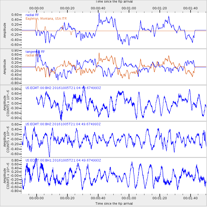
Signal To Noise
| Channel | StoN | STA | LTA |
| US:EGMT:00:BHZ:20161005T21:04:49.674993Z | 0.65003395 | 1.6778755E-7 | 2.581212E-7 |
| US:EGMT:00:BH1:20161005T21:04:49.674993Z | 1.3424749 | 5.8312594E-7 | 4.3436634E-7 |
| US:EGMT:00:BH2:20161005T21:04:49.674993Z | 1.3691665 | 4.9803396E-7 | 3.6374976E-7 |
| Arrivals |
| Ps | |
| PpPs | |
| PsPs/PpSs | |


