You are here: Home > Network List > US - United States National Seismic Network Stations List
> Station HAWA Hanford, Washington, USA > Earthquake Result Viewer
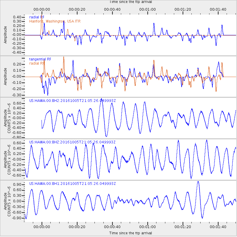
HAWA Hanford, Washington, USA - Earthquake Result Viewer
*The percent match for this event was below the threshold and hence no stack was calculated.
| Earthquake location: |
Central Mid-Atlantic Ridge |
| Earthquake latitude/longitude: |
7.1/-34.3 |
| Earthquake time(UTC): |
2016/10/05 (279) 20:53:39 GMT |
| Earthquake Depth: |
10 km |
| Earthquake Magnitude: |
5.5 mwb |
| Earthquake Catalog/Contributor: |
NEIC PDE/ |
|
| Network: |
US United States National Seismic Network |
| Station: |
HAWA Hanford, Washington, USA |
| Lat/Lon: |
46.39 N/119.53 W |
| Elevation: |
364 m |
|
| Distance: |
81.6 deg |
| Az: |
315.793 deg |
| Baz: |
88.507 deg |
| Ray Param: |
$rayparam |
*The percent match for this event was below the threshold and hence was not used in the summary stack. |
|
| Radial Match: |
75.29527 % |
| Radial Bump: |
400 |
| Transverse Match: |
64.22176 % |
| Transverse Bump: |
400 |
| SOD ConfigId: |
11737051 |
| Insert Time: |
2019-04-25 16:53:27.273 +0000 |
| GWidth: |
2.5 |
| Max Bumps: |
400 |
| Tol: |
0.001 |
|
Signal To Noise
| Channel | StoN | STA | LTA |
| US:HAWA:00:BHZ:20161005T21:05:26.049993Z | 0.548073 | 2.390688E-7 | 4.361988E-7 |
| US:HAWA:00:BH1:20161005T21:05:26.049993Z | 0.87269413 | 3.5828083E-7 | 4.105457E-7 |
| US:HAWA:00:BH2:20161005T21:05:26.049993Z | 1.9997048 | 4.988741E-7 | 2.4947386E-7 |
| Arrivals |
| Ps | |
| PpPs | |
| PsPs/PpSs | |


