You are here: Home > Network List > US - United States National Seismic Network Stations List
> Station EGMT Eagleton, Montana, USA > Earthquake Result Viewer
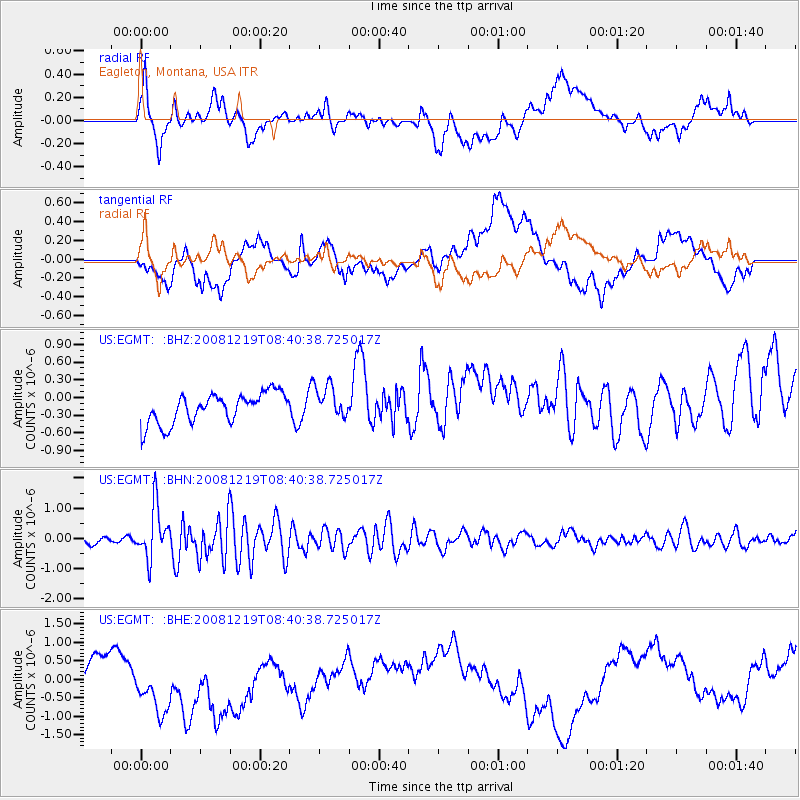
EGMT Eagleton, Montana, USA - Earthquake Result Viewer
*The percent match for this event was below the threshold and hence no stack was calculated.
| Earthquake location: |
Northern Mid-Atlantic Ridge |
| Earthquake latitude/longitude: |
47.0/-27.3 |
| Earthquake time(UTC): |
2008/12/19 (354) 08:31:51 GMT |
| Earthquake Depth: |
2.0 km |
| Earthquake Magnitude: |
5.8 MB, 5.6 MS, 5.9 MW, 5.8 MW |
| Earthquake Catalog/Contributor: |
WHDF/NEIC |
|
| Network: |
US United States National Seismic Network |
| Station: |
EGMT Eagleton, Montana, USA |
| Lat/Lon: |
48.02 N/109.75 W |
| Elevation: |
1055 m |
|
| Distance: |
53.1 deg |
| Az: |
303.657 deg |
| Baz: |
58.065 deg |
| Ray Param: |
$rayparam |
*The percent match for this event was below the threshold and hence was not used in the summary stack. |
|
| Radial Match: |
45.968613 % |
| Radial Bump: |
400 |
| Transverse Match: |
24.435377 % |
| Transverse Bump: |
400 |
| SOD ConfigId: |
2658 |
| Insert Time: |
2010-03-05 07:28:19.542 +0000 |
| GWidth: |
2.5 |
| Max Bumps: |
400 |
| Tol: |
0.001 |
|
Signal To Noise
| Channel | StoN | STA | LTA |
| US:EGMT: :BHN:20081219T08:40:38.725017Z | 7.092139 | 8.4774723E-7 | 1.1953337E-7 |
| US:EGMT: :BHE:20081219T08:40:38.725017Z | 2.9877813 | 1.3759095E-6 | 4.6051213E-7 |
| US:EGMT: :BHZ:20081219T08:40:38.725017Z | 1.0841963 | 2.777615E-7 | 2.5619113E-7 |
| Arrivals |
| Ps | |
| PpPs | |
| PsPs/PpSs | |


