You are here: Home > Network List > US - United States National Seismic Network Stations List
> Station EGMT Eagleton, Montana, USA > Earthquake Result Viewer
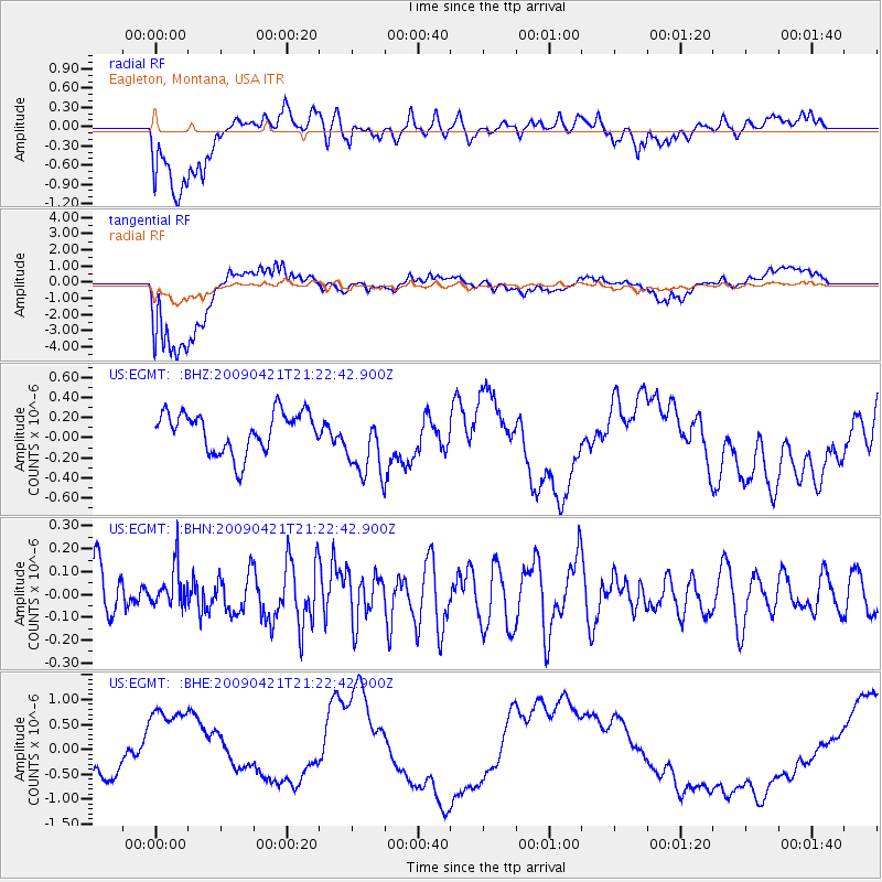
EGMT Eagleton, Montana, USA - Earthquake Result Viewer
*The percent match for this event was below the threshold and hence no stack was calculated.
| Earthquake location: |
Santa Cruz Islands |
| Earthquake latitude/longitude: |
-10.8/166.0 |
| Earthquake time(UTC): |
2009/04/21 (111) 21:09:59 GMT |
| Earthquake Depth: |
35 km |
| Earthquake Magnitude: |
5.7 MW, 5.0 MS, 5.3 MB, 5.7 MW |
| Earthquake Catalog/Contributor: |
WHDF/NEIC |
|
| Network: |
US United States National Seismic Network |
| Station: |
EGMT Eagleton, Montana, USA |
| Lat/Lon: |
48.02 N/109.75 W |
| Elevation: |
1055 m |
|
| Distance: |
94.1 deg |
| Az: |
42.036 deg |
| Baz: |
258.532 deg |
| Ray Param: |
$rayparam |
*The percent match for this event was below the threshold and hence was not used in the summary stack. |
|
| Radial Match: |
49.33814 % |
| Radial Bump: |
400 |
| Transverse Match: |
39.426662 % |
| Transverse Bump: |
400 |
| SOD ConfigId: |
2658 |
| Insert Time: |
2010-03-05 07:28:20.360 +0000 |
| GWidth: |
2.5 |
| Max Bumps: |
400 |
| Tol: |
0.001 |
|
Signal To Noise
| Channel | StoN | STA | LTA |
| US:EGMT: :BHN:20090421T21:22:42.900Z | 0.7394101 | 8.8606456E-8 | 1.1983398E-7 |
| US:EGMT: :BHE:20090421T21:22:42.900Z | 2.557631 | 1.0473657E-6 | 4.0950616E-7 |
| US:EGMT: :BHZ:20090421T21:22:42.900Z | 1.7409817 | 3.459602E-7 | 1.9871558E-7 |
| Arrivals |
| Ps | |
| PpPs | |
| PsPs/PpSs | |


