You are here: Home > Network List > US - United States National Seismic Network Stations List
> Station EGMT Eagleton, Montana, USA > Earthquake Result Viewer
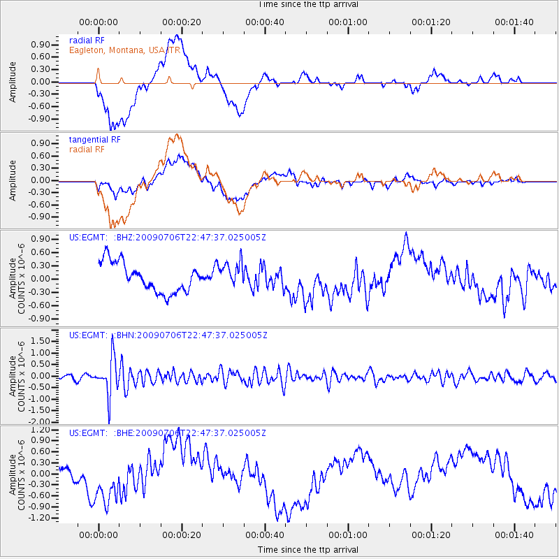
EGMT Eagleton, Montana, USA - Earthquake Result Viewer
*The percent match for this event was below the threshold and hence no stack was calculated.
| Earthquake location: |
Southeast Of Ryukyu Islands |
| Earthquake latitude/longitude: |
24.9/128.0 |
| Earthquake time(UTC): |
2009/07/06 (187) 22:35:05 GMT |
| Earthquake Depth: |
10 km |
| Earthquake Magnitude: |
6.1 MB, 5.3 MS, 5.7 MW, 5.7 MW |
| Earthquake Catalog/Contributor: |
WHDF/NEIC |
|
| Network: |
US United States National Seismic Network |
| Station: |
EGMT Eagleton, Montana, USA |
| Lat/Lon: |
48.02 N/109.75 W |
| Elevation: |
1055 m |
|
| Distance: |
90.9 deg |
| Az: |
34.611 deg |
| Baz: |
309.777 deg |
| Ray Param: |
$rayparam |
*The percent match for this event was below the threshold and hence was not used in the summary stack. |
|
| Radial Match: |
24.799511 % |
| Radial Bump: |
400 |
| Transverse Match: |
37.22055 % |
| Transverse Bump: |
400 |
| SOD ConfigId: |
2648 |
| Insert Time: |
2010-03-05 07:28:24.026 +0000 |
| GWidth: |
2.5 |
| Max Bumps: |
400 |
| Tol: |
0.001 |
|
Signal To Noise
| Channel | StoN | STA | LTA |
| US:EGMT: :BHN:20090706T22:47:37.025005Z | 8.288568 | 8.100289E-7 | 9.772845E-8 |
| US:EGMT: :BHE:20090706T22:47:37.025005Z | 1.3373846 | 5.540168E-7 | 4.1425395E-7 |
| US:EGMT: :BHZ:20090706T22:47:37.025005Z | 0.8390233 | 2.7335258E-7 | 3.2579857E-7 |
| Arrivals |
| Ps | |
| PpPs | |
| PsPs/PpSs | |


