You are here: Home > Network List > US - United States National Seismic Network Stations List
> Station EGMT Eagleton, Montana, USA > Earthquake Result Viewer
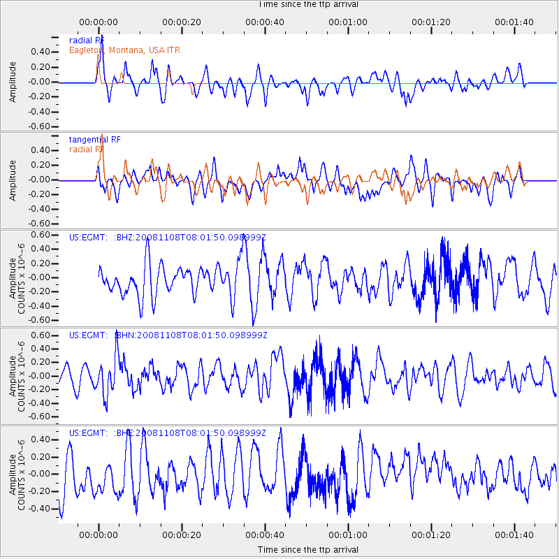
EGMT Eagleton, Montana, USA - Earthquake Result Viewer
*The percent match for this event was below the threshold and hence no stack was calculated.
| Earthquake location: |
Tonga Islands |
| Earthquake latitude/longitude: |
-15.2/-174.2 |
| Earthquake time(UTC): |
2008/11/08 (313) 07:49:59 GMT |
| Earthquake Depth: |
121 km |
| Earthquake Magnitude: |
6.0 MW, 5.4 MB, 6.0 MW |
| Earthquake Catalog/Contributor: |
WHDF/NEIC |
|
| Network: |
US United States National Seismic Network |
| Station: |
EGMT Eagleton, Montana, USA |
| Lat/Lon: |
48.02 N/109.75 W |
| Elevation: |
1055 m |
|
| Distance: |
85.1 deg |
| Az: |
37.447 deg |
| Baz: |
240.971 deg |
| Ray Param: |
$rayparam |
*The percent match for this event was below the threshold and hence was not used in the summary stack. |
|
| Radial Match: |
61.66453 % |
| Radial Bump: |
400 |
| Transverse Match: |
41.557606 % |
| Transverse Bump: |
400 |
| SOD ConfigId: |
2658 |
| Insert Time: |
2010-03-05 07:28:39.807 +0000 |
| GWidth: |
2.5 |
| Max Bumps: |
400 |
| Tol: |
0.001 |
|
Signal To Noise
| Channel | StoN | STA | LTA |
| US:EGMT: :BHN:20081108T08:01:50.098999Z | 2.72697 | 2.8789182E-7 | 1.05572056E-7 |
| US:EGMT: :BHE:20081108T08:01:50.098999Z | 0.6976829 | 1.8742365E-7 | 2.686373E-7 |
| US:EGMT: :BHZ:20081108T08:01:50.098999Z | 1.422395 | 2.897924E-7 | 2.0373554E-7 |
| Arrivals |
| Ps | |
| PpPs | |
| PsPs/PpSs | |


