You are here: Home > Network List > US - United States National Seismic Network Stations List
> Station EGMT Eagleton, Montana, USA > Earthquake Result Viewer
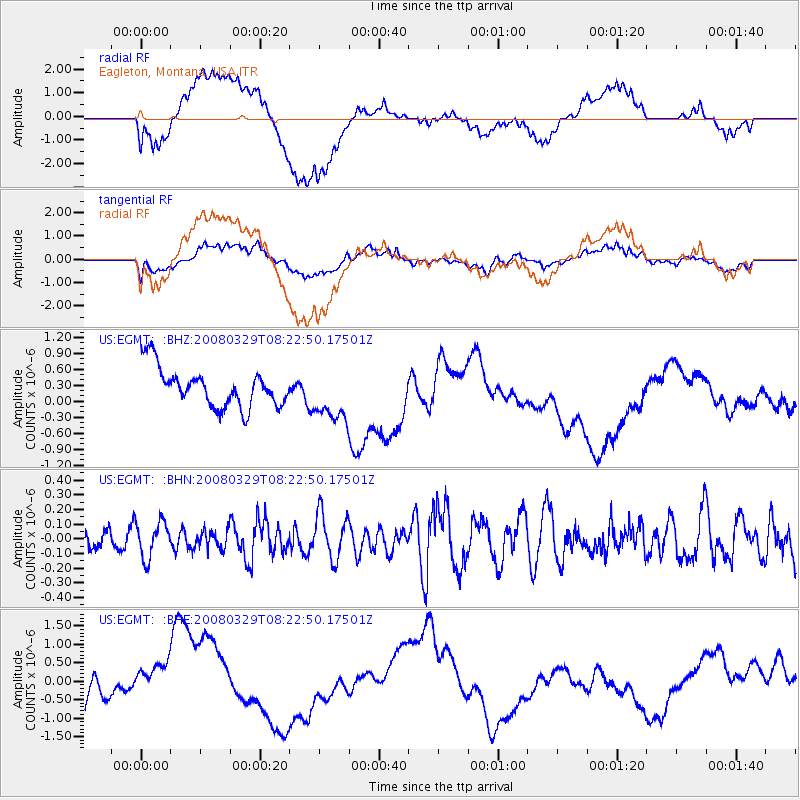
EGMT Eagleton, Montana, USA - Earthquake Result Viewer
*The percent match for this event was below the threshold and hence no stack was calculated.
| Earthquake location: |
Philippine Islands Region |
| Earthquake latitude/longitude: |
20.3/122.0 |
| Earthquake time(UTC): |
2008/03/29 (089) 08:09:47 GMT |
| Earthquake Depth: |
16 km |
| Earthquake Magnitude: |
5.5 MB, 5.3 MS, 5.5 MW |
| Earthquake Catalog/Contributor: |
WHDF/NEIC |
|
| Network: |
US United States National Seismic Network |
| Station: |
EGMT Eagleton, Montana, USA |
| Lat/Lon: |
48.02 N/109.75 W |
| Elevation: |
1055 m |
|
| Distance: |
97.8 deg |
| Az: |
32.139 deg |
| Baz: |
311.93 deg |
| Ray Param: |
$rayparam |
*The percent match for this event was below the threshold and hence was not used in the summary stack. |
|
| Radial Match: |
31.053688 % |
| Radial Bump: |
400 |
| Transverse Match: |
34.90609 % |
| Transverse Bump: |
400 |
| SOD ConfigId: |
2504 |
| Insert Time: |
2010-03-05 07:28:48.096 +0000 |
| GWidth: |
2.5 |
| Max Bumps: |
400 |
| Tol: |
0.001 |
|
Signal To Noise
| Channel | StoN | STA | LTA |
| US:EGMT: :BHN:20080329T08:22:50.17501Z | 1.2707419 | 1.2161722E-7 | 9.570569E-8 |
| US:EGMT: :BHE:20080329T08:22:50.17501Z | 1.0812596 | 8.721821E-7 | 8.066352E-7 |
| US:EGMT: :BHZ:20080329T08:22:50.17501Z | 1.356402 | 4.955582E-7 | 3.6534755E-7 |
| Arrivals |
| Ps | |
| PpPs | |
| PsPs/PpSs | |


