You are here: Home > Network List > US - United States National Seismic Network Stations List
> Station EGMT Eagleton, Montana, USA > Earthquake Result Viewer
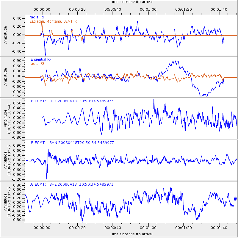
EGMT Eagleton, Montana, USA - Earthquake Result Viewer
*The percent match for this event was below the threshold and hence no stack was calculated.
| Earthquake location: |
Fiji Islands Region |
| Earthquake latitude/longitude: |
-17.3/-179.0 |
| Earthquake time(UTC): |
2008/04/18 (109) 20:39:07 GMT |
| Earthquake Depth: |
554 km |
| Earthquake Magnitude: |
5.9 MB, 6.3 MW, 6.3 MW |
| Earthquake Catalog/Contributor: |
WHDF/NEIC |
|
| Network: |
US United States National Seismic Network |
| Station: |
EGMT Eagleton, Montana, USA |
| Lat/Lon: |
48.02 N/109.75 W |
| Elevation: |
1055 m |
|
| Distance: |
89.6 deg |
| Az: |
38.891 deg |
| Baz: |
243.289 deg |
| Ray Param: |
$rayparam |
*The percent match for this event was below the threshold and hence was not used in the summary stack. |
|
| Radial Match: |
51.65496 % |
| Radial Bump: |
400 |
| Transverse Match: |
36.330795 % |
| Transverse Bump: |
400 |
| SOD ConfigId: |
2504 |
| Insert Time: |
2010-03-05 07:28:50.465 +0000 |
| GWidth: |
2.5 |
| Max Bumps: |
400 |
| Tol: |
0.001 |
|
Signal To Noise
| Channel | StoN | STA | LTA |
| US:EGMT: :BHN:20080418T20:50:34.548997Z | 4.4193 | 4.3360154E-7 | 9.8115436E-8 |
| US:EGMT: :BHE:20080418T20:50:34.548997Z | 0.61712366 | 1.4193289E-7 | 2.2999099E-7 |
| US:EGMT: :BHZ:20080418T20:50:34.548997Z | 1.8030202 | 2.7576738E-7 | 1.5294746E-7 |
| Arrivals |
| Ps | |
| PpPs | |
| PsPs/PpSs | |


