You are here: Home > Network List > CN - Canadian National Seismograph Network Stations List
> Station INK INUVIK, NT > Earthquake Result Viewer
INK INUVIK, NT - Earthquake Result Viewer
*The percent match for this event was below the threshold and hence no stack was calculated.
| Earthquake location: |
Taiwan Region |
| Earthquake latitude/longitude: |
22.6/121.4 |
| Earthquake time(UTC): |
2016/10/06 (280) 15:52:00 GMT |
| Earthquake Depth: |
17 km |
| Earthquake Magnitude: |
5.7 MO |
| Earthquake Catalog/Contributor: |
NEIC PDE/NEIC ALERT |
|
| Network: |
CN Canadian National Seismograph Network |
| Station: |
INK INUVIK, NT |
| Lat/Lon: |
68.31 N/133.53 W |
| Elevation: |
44 m |
|
| Distance: |
74.6 deg |
| Az: |
21.868 deg |
| Baz: |
292.226 deg |
| Ray Param: |
$rayparam |
*The percent match for this event was below the threshold and hence was not used in the summary stack. |
|
| Radial Match: |
60.346985 % |
| Radial Bump: |
400 |
| Transverse Match: |
48.258884 % |
| Transverse Bump: |
400 |
| SOD ConfigId: |
11737051 |
| Insert Time: |
2019-04-25 16:58:13.828 +0000 |
| GWidth: |
2.5 |
| Max Bumps: |
400 |
| Tol: |
0.001 |
|
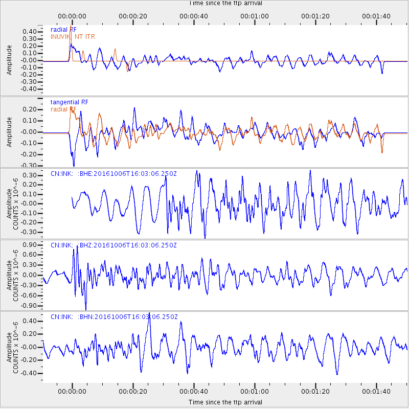
Signal To Noise
| Channel | StoN | STA | LTA |
| CN:INK: :BHZ:20161006T16:03:06.250Z | 4.362745 | 4.782458E-7 | 1.0962039E-7 |
| CN:INK: :BHN:20161006T16:03:06.250Z | 1.0683341 | 1.1982847E-7 | 1.1216385E-7 |
| CN:INK: :BHE:20161006T16:03:06.250Z | 1.4036809 | 1.6799163E-7 | 1.1967936E-7 |
| Arrivals |
| Ps | |
| PpPs | |
| PsPs/PpSs | |


