You are here: Home > Network List > TA - USArray Transportable Network (new EarthScope stations) Stations List
> Station A21K Barrow, AK, USA > Earthquake Result Viewer
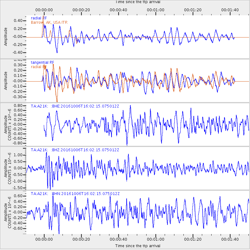
A21K Barrow, AK, USA - Earthquake Result Viewer
*The percent match for this event was below the threshold and hence no stack was calculated.
| Earthquake location: |
Taiwan Region |
| Earthquake latitude/longitude: |
22.6/121.4 |
| Earthquake time(UTC): |
2016/10/06 (280) 15:52:00 GMT |
| Earthquake Depth: |
17 km |
| Earthquake Magnitude: |
5.7 MO |
| Earthquake Catalog/Contributor: |
NEIC PDE/NEIC ALERT |
|
| Network: |
TA USArray Transportable Network (new EarthScope stations) |
| Station: |
A21K Barrow, AK, USA |
| Lat/Lon: |
71.32 N/156.62 W |
| Elevation: |
577 m |
|
| Distance: |
66.2 deg |
| Az: |
20.407 deg |
| Baz: |
270.035 deg |
| Ray Param: |
$rayparam |
*The percent match for this event was below the threshold and hence was not used in the summary stack. |
|
| Radial Match: |
65.4861 % |
| Radial Bump: |
400 |
| Transverse Match: |
66.98832 % |
| Transverse Bump: |
400 |
| SOD ConfigId: |
11737051 |
| Insert Time: |
2019-04-25 17:01:09.670 +0000 |
| GWidth: |
2.5 |
| Max Bumps: |
400 |
| Tol: |
0.001 |
|
Signal To Noise
| Channel | StoN | STA | LTA |
| TA:A21K: :BHZ:20161006T16:02:15.075012Z | 4.141837 | 7.624999E-7 | 1.8409703E-7 |
| TA:A21K: :BHN:20161006T16:02:15.075012Z | 1.9725591 | 3.1154144E-7 | 1.579377E-7 |
| TA:A21K: :BHE:20161006T16:02:15.075012Z | 0.9536066 | 2.3298317E-7 | 2.443179E-7 |
| Arrivals |
| Ps | |
| PpPs | |
| PsPs/PpSs | |


