You are here: Home > Network List > US - United States National Seismic Network Stations List
> Station EGMT Eagleton, Montana, USA > Earthquake Result Viewer
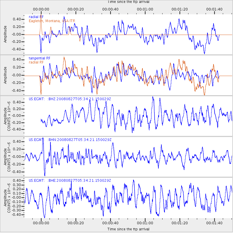
EGMT Eagleton, Montana, USA - Earthquake Result Viewer
*The percent match for this event was below the threshold and hence no stack was calculated.
| Earthquake location: |
Kuril Islands |
| Earthquake latitude/longitude: |
46.7/152.5 |
| Earthquake time(UTC): |
2008/08/27 (240) 05:24:41 GMT |
| Earthquake Depth: |
65 km |
| Earthquake Magnitude: |
5.5 MB, 5.4 MW, 5.3 MW |
| Earthquake Catalog/Contributor: |
WHDF/NEIC |
|
| Network: |
US United States National Seismic Network |
| Station: |
EGMT Eagleton, Montana, USA |
| Lat/Lon: |
48.02 N/109.75 W |
| Elevation: |
1055 m |
|
| Distance: |
61.6 deg |
| Az: |
49.124 deg |
| Baz: |
309.207 deg |
| Ray Param: |
$rayparam |
*The percent match for this event was below the threshold and hence was not used in the summary stack. |
|
| Radial Match: |
44.342056 % |
| Radial Bump: |
400 |
| Transverse Match: |
55.26478 % |
| Transverse Bump: |
400 |
| SOD ConfigId: |
2504 |
| Insert Time: |
2010-03-05 07:29:14.460 +0000 |
| GWidth: |
2.5 |
| Max Bumps: |
400 |
| Tol: |
0.001 |
|
Signal To Noise
| Channel | StoN | STA | LTA |
| US:EGMT: :BHN:20080827T05:34:21.150029Z | 2.8978791 | 2.3126321E-7 | 7.9804295E-8 |
| US:EGMT: :BHE:20080827T05:34:21.150029Z | 2.389497 | 2.2291036E-7 | 9.328756E-8 |
| US:EGMT: :BHZ:20080827T05:34:21.150029Z | 1.7476754 | 2.7304233E-7 | 1.5623172E-7 |
| Arrivals |
| Ps | |
| PpPs | |
| PsPs/PpSs | |


