You are here: Home > Network List > TJ - Tajikistan National Seismic Network Stations List
> Station SHAA Shaartuz, Tajikistan > Earthquake Result Viewer
SHAA Shaartuz, Tajikistan - Earthquake Result Viewer
| Earthquake location: |
Taiwan Region |
| Earthquake latitude/longitude: |
22.6/121.4 |
| Earthquake time(UTC): |
2016/10/06 (280) 15:52:00 GMT |
| Earthquake Depth: |
17 km |
| Earthquake Magnitude: |
5.7 MO |
| Earthquake Catalog/Contributor: |
NEIC PDE/NEIC ALERT |
|
| Network: |
TJ Tajikistan National Seismic Network |
| Station: |
SHAA Shaartuz, Tajikistan |
| Lat/Lon: |
37.56 N/68.12 E |
| Elevation: |
868 m |
|
| Distance: |
47.9 deg |
| Az: |
300.765 deg |
| Baz: |
92.409 deg |
| Ray Param: |
0.069696605 |
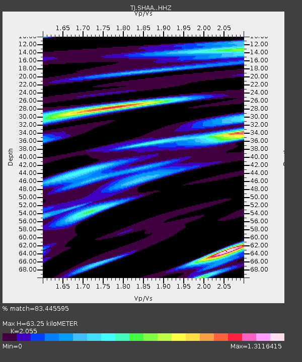
| Estimated Moho Depth: |
63.25 km |
| Estimated Crust Vp/Vs: |
2.06 |
| Assumed Crust Vp: |
6.213 km/s |
| Estimated Crust Vs: |
3.024 km/s |
| Estimated Crust Poisson's Ratio: |
0.34 |
|
| Radial Match: |
83.445595 % |
| Radial Bump: |
400 |
| Transverse Match: |
70.93828 % |
| Transverse Bump: |
400 |
| SOD ConfigId: |
11737051 |
| Insert Time: |
2019-04-25 17:02:23.953 +0000 |
| GWidth: |
2.5 |
| Max Bumps: |
400 |
| Tol: |
0.001 |
|
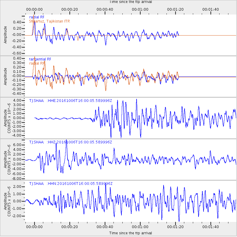
Signal To Noise
| Channel | StoN | STA | LTA |
| TJ:SHAA: :HHZ:20161006T16:00:05.589996Z | 10.875615 | 1.5594289E-6 | 1.4338765E-7 |
| TJ:SHAA: :HHN:20161006T16:00:05.589996Z | 2.1326973 | 2.2769665E-7 | 1.0676463E-7 |
| TJ:SHAA: :HHE:20161006T16:00:05.589996Z | 6.1411033 | 5.707232E-7 | 9.293497E-8 |
| Arrivals |
| Ps | 11 SECOND |
| PpPs | 30 SECOND |
| PsPs/PpSs | 41 SECOND |


