You are here: Home > Network List > IU - Global Seismograph Network (GSN - IRIS/USGS) Stations List
> Station PMG Port Moresby, New Guinea > Earthquake Result Viewer
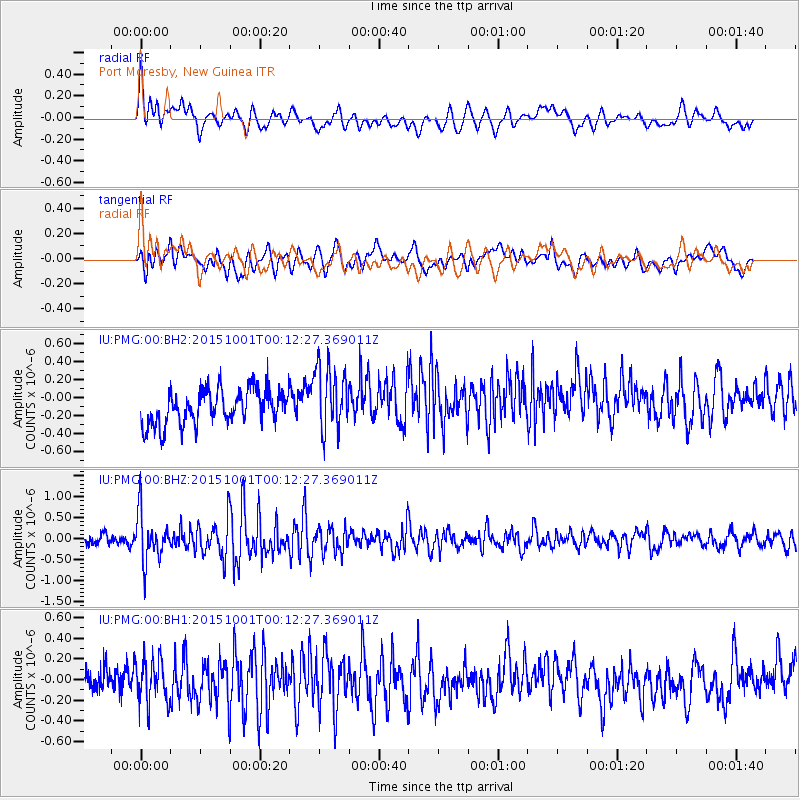
PMG Port Moresby, New Guinea - Earthquake Result Viewer
*The percent match for this event was below the threshold and hence no stack was calculated.
| Earthquake location: |
Southwest Of Sumatra, Indonesia |
| Earthquake latitude/longitude: |
-6.0/103.7 |
| Earthquake time(UTC): |
2015/10/01 (274) 00:04:58 GMT |
| Earthquake Depth: |
19 km |
| Earthquake Magnitude: |
5.8 MB |
| Earthquake Catalog/Contributor: |
NEIC PDE/NEIC COMCAT |
|
| Network: |
IU Global Seismograph Network (GSN - IRIS/USGS) |
| Station: |
PMG Port Moresby, New Guinea |
| Lat/Lon: |
9.40 S/147.16 E |
| Elevation: |
90 m |
|
| Distance: |
43.2 deg |
| Az: |
97.278 deg |
| Baz: |
271.184 deg |
| Ray Param: |
$rayparam |
*The percent match for this event was below the threshold and hence was not used in the summary stack. |
|
| Radial Match: |
56.17898 % |
| Radial Bump: |
400 |
| Transverse Match: |
68.33027 % |
| Transverse Bump: |
400 |
| SOD ConfigId: |
1156111 |
| Insert Time: |
2015-10-15 00:22:00.216 +0000 |
| GWidth: |
2.5 |
| Max Bumps: |
400 |
| Tol: |
0.001 |
|
Signal To Noise
| Channel | StoN | STA | LTA |
| IU:PMG:00:BHZ:20151001T00:12:27.369011Z | 4.6578097 | 5.794045E-7 | 1.243942E-7 |
| IU:PMG:00:BH1:20151001T00:12:27.369011Z | 1.9853323 | 2.1803187E-7 | 1.0982135E-7 |
| IU:PMG:00:BH2:20151001T00:12:27.369011Z | 1.8810279 | 3.6319105E-7 | 1.9308116E-7 |
| Arrivals |
| Ps | |
| PpPs | |
| PsPs/PpSs | |


