You are here: Home > Network List > UW - Pacific Northwest Regional Seismic Network Stations List
> Station UMAT Pilot Rock, OR, USA > Earthquake Result Viewer
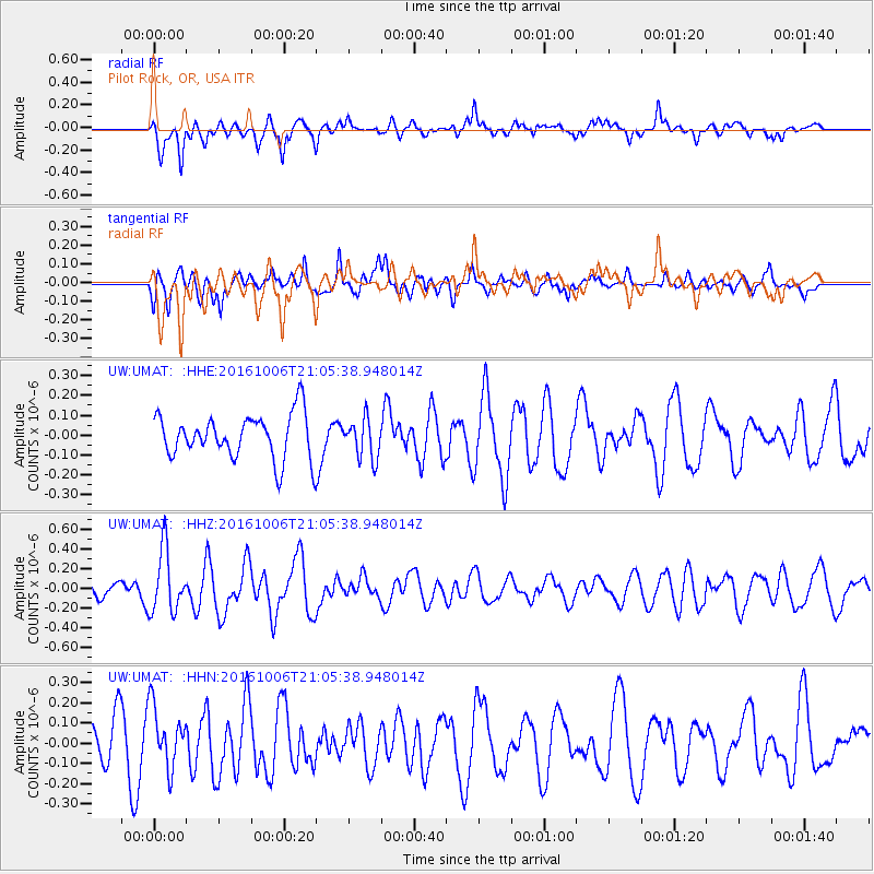
UMAT Pilot Rock, OR, USA - Earthquake Result Viewer
*The percent match for this event was below the threshold and hence no stack was calculated.
| Earthquake location: |
Central East Pacific Rise |
| Earthquake latitude/longitude: |
-4.0/-103.9 |
| Earthquake time(UTC): |
2016/10/06 (280) 20:57:08 GMT |
| Earthquake Depth: |
10 km |
| Earthquake Magnitude: |
5.6 mwb |
| Earthquake Catalog/Contributor: |
NEIC PDE/ |
|
| Network: |
UW Pacific Northwest Regional Seismic Network |
| Station: |
UMAT Pilot Rock, OR, USA |
| Lat/Lon: |
45.29 N/118.96 W |
| Elevation: |
1318 m |
|
| Distance: |
50.9 deg |
| Az: |
346.348 deg |
| Baz: |
160.517 deg |
| Ray Param: |
$rayparam |
*The percent match for this event was below the threshold and hence was not used in the summary stack. |
|
| Radial Match: |
64.42901 % |
| Radial Bump: |
388 |
| Transverse Match: |
53.922745 % |
| Transverse Bump: |
400 |
| SOD ConfigId: |
11737051 |
| Insert Time: |
2019-04-25 17:13:25.341 +0000 |
| GWidth: |
2.5 |
| Max Bumps: |
400 |
| Tol: |
0.001 |
|
Signal To Noise
| Channel | StoN | STA | LTA |
| UW:UMAT: :HHZ:20161006T21:05:38.948014Z | 3.2442615 | 3.1512494E-7 | 9.7133025E-8 |
| UW:UMAT: :HHN:20161006T21:05:38.948014Z | 1.9023954 | 1.5069296E-7 | 7.9212214E-8 |
| UW:UMAT: :HHE:20161006T21:05:38.948014Z | 0.9003785 | 1.00055274E-7 | 1.11125786E-7 |
| Arrivals |
| Ps | |
| PpPs | |
| PsPs/PpSs | |


