You are here: Home > Network List > TA - USArray Transportable Network (new EarthScope stations) Stations List
> Station J20K Nowitna River, AK, USA > Earthquake Result Viewer
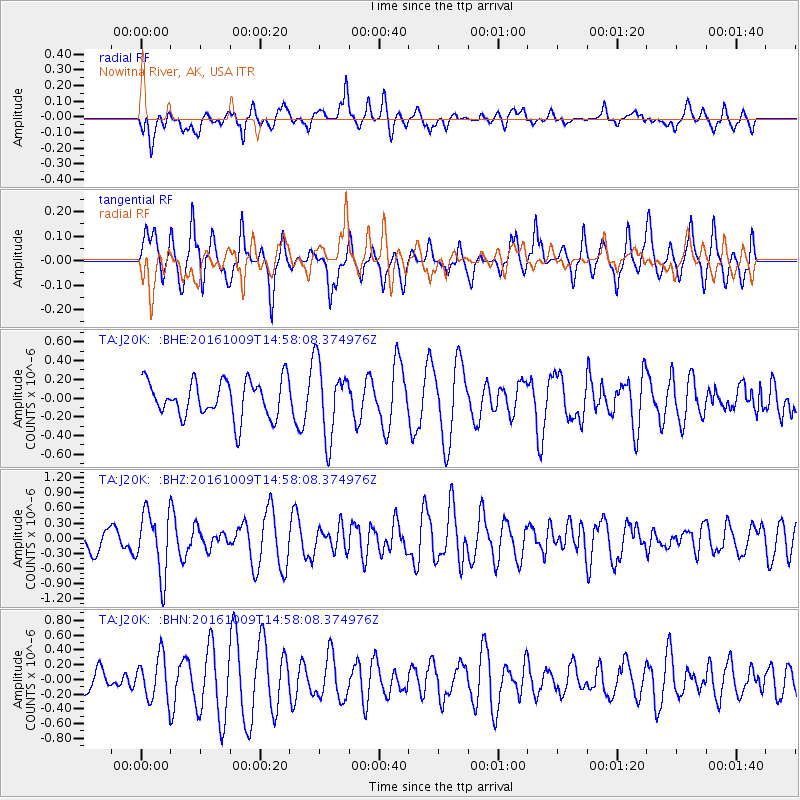
J20K Nowitna River, AK, USA - Earthquake Result Viewer
*The percent match for this event was below the threshold and hence no stack was calculated.
| Earthquake location: |
Halmahera, Indonesia |
| Earthquake latitude/longitude: |
1.8/127.5 |
| Earthquake time(UTC): |
2016/10/09 (283) 14:46:25 GMT |
| Earthquake Depth: |
116 km |
| Earthquake Magnitude: |
5.7 MB, 5.8 MWB |
| Earthquake Catalog/Contributor: |
NEIC PDE/NEIC COMCAT |
|
| Network: |
TA USArray Transportable Network (new EarthScope stations) |
| Station: |
J20K Nowitna River, AK, USA |
| Lat/Lon: |
64.18 N/154.15 W |
| Elevation: |
314 m |
|
| Distance: |
83.3 deg |
| Az: |
25.586 deg |
| Baz: |
260.264 deg |
| Ray Param: |
$rayparam |
*The percent match for this event was below the threshold and hence was not used in the summary stack. |
|
| Radial Match: |
54.27054 % |
| Radial Bump: |
400 |
| Transverse Match: |
61.910053 % |
| Transverse Bump: |
361 |
| SOD ConfigId: |
11737051 |
| Insert Time: |
2019-04-25 17:24:26.045 +0000 |
| GWidth: |
2.5 |
| Max Bumps: |
400 |
| Tol: |
0.001 |
|
Signal To Noise
| Channel | StoN | STA | LTA |
| TA:J20K: :BHZ:20161009T14:58:08.374976Z | 2.0991218 | 6.230978E-7 | 2.9683736E-7 |
| TA:J20K: :BHN:20161009T14:58:08.374976Z | 1.3669766 | 2.9931928E-7 | 2.1896446E-7 |
| TA:J20K: :BHE:20161009T14:58:08.374976Z | 2.0500493 | 4.0179935E-7 | 1.9599499E-7 |
| Arrivals |
| Ps | |
| PpPs | |
| PsPs/PpSs | |


