You are here: Home > Network List > TA - USArray Transportable Network (new EarthScope stations) Stations List
> Station O17K Koliganek, Bristol Bay, AK, USA > Earthquake Result Viewer
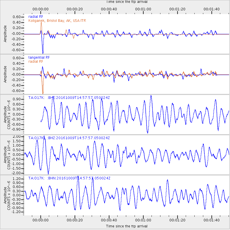
O17K Koliganek, Bristol Bay, AK, USA - Earthquake Result Viewer
*The percent match for this event was below the threshold and hence no stack was calculated.
| Earthquake location: |
Halmahera, Indonesia |
| Earthquake latitude/longitude: |
1.8/127.5 |
| Earthquake time(UTC): |
2016/10/09 (283) 14:46:25 GMT |
| Earthquake Depth: |
116 km |
| Earthquake Magnitude: |
5.7 MB, 5.8 MWB |
| Earthquake Catalog/Contributor: |
NEIC PDE/NEIC COMCAT |
|
| Network: |
TA USArray Transportable Network (new EarthScope stations) |
| Station: |
O17K Koliganek, Bristol Bay, AK, USA |
| Lat/Lon: |
59.77 N/157.09 W |
| Elevation: |
156 m |
|
| Distance: |
81.1 deg |
| Az: |
29.705 deg |
| Baz: |
258.22 deg |
| Ray Param: |
$rayparam |
*The percent match for this event was below the threshold and hence was not used in the summary stack. |
|
| Radial Match: |
82.441795 % |
| Radial Bump: |
400 |
| Transverse Match: |
73.9766 % |
| Transverse Bump: |
400 |
| SOD ConfigId: |
11737051 |
| Insert Time: |
2019-04-25 17:24:37.483 +0000 |
| GWidth: |
2.5 |
| Max Bumps: |
400 |
| Tol: |
0.001 |
|
Signal To Noise
| Channel | StoN | STA | LTA |
| TA:O17K: :BHZ:20161009T14:57:57.050024Z | 2.6024485 | 1.3738894E-6 | 5.279218E-7 |
| TA:O17K: :BHN:20161009T14:57:57.050024Z | 0.9582828 | 4.317137E-7 | 4.505076E-7 |
| TA:O17K: :BHE:20161009T14:57:57.050024Z | 1.2181481 | 5.5572355E-7 | 4.562036E-7 |
| Arrivals |
| Ps | |
| PpPs | |
| PsPs/PpSs | |


