You are here: Home > Network List > TJ - Tajikistan National Seismic Network Stations List
> Station GARM Garm, Tajikistan > Earthquake Result Viewer
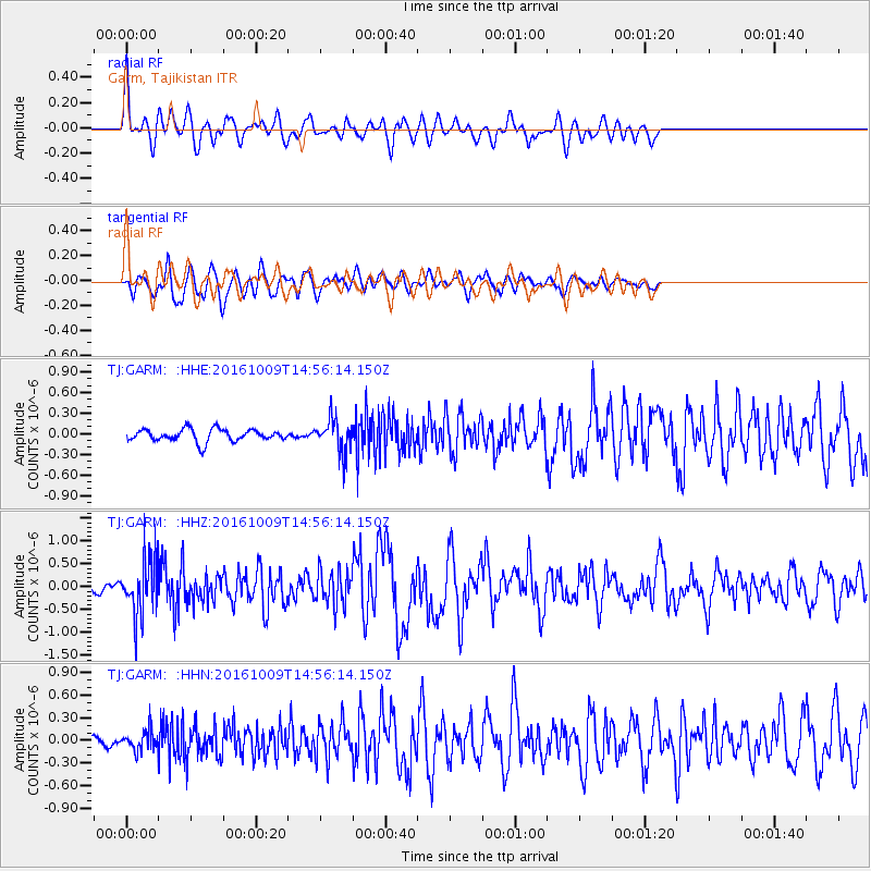
GARM Garm, Tajikistan - Earthquake Result Viewer
*The percent match for this event was below the threshold and hence no stack was calculated.
| Earthquake location: |
Halmahera, Indonesia |
| Earthquake latitude/longitude: |
1.8/127.5 |
| Earthquake time(UTC): |
2016/10/09 (283) 14:46:25 GMT |
| Earthquake Depth: |
116 km |
| Earthquake Magnitude: |
5.7 MB, 5.8 MWB |
| Earthquake Catalog/Contributor: |
NEIC PDE/NEIC COMCAT |
|
| Network: |
TJ Tajikistan National Seismic Network |
| Station: |
GARM Garm, Tajikistan |
| Lat/Lon: |
39.00 N/70.32 E |
| Elevation: |
1305 m |
|
| Distance: |
63.8 deg |
| Az: |
313.129 deg |
| Baz: |
110.583 deg |
| Ray Param: |
$rayparam |
*The percent match for this event was below the threshold and hence was not used in the summary stack. |
|
| Radial Match: |
72.92527 % |
| Radial Bump: |
400 |
| Transverse Match: |
77.84146 % |
| Transverse Bump: |
400 |
| SOD ConfigId: |
11737051 |
| Insert Time: |
2019-04-25 17:24:47.213 +0000 |
| GWidth: |
2.5 |
| Max Bumps: |
400 |
| Tol: |
0.001 |
|
Signal To Noise
| Channel | StoN | STA | LTA |
| TJ:GARM: :HHZ:20161009T14:56:14.150Z | 5.5721383 | 6.0621863E-7 | 1.0879461E-7 |
| TJ:GARM: :HHN:20161009T14:56:14.150Z | 1.9181435 | 1.3820258E-7 | 7.205018E-8 |
| TJ:GARM: :HHE:20161009T14:56:14.150Z | 2.7922816 | 2.470123E-7 | 8.8462535E-8 |
| Arrivals |
| Ps | |
| PpPs | |
| PsPs/PpSs | |


