You are here: Home > Network List > CI - Caltech Regional Seismic Network Stations List
> Station MPP McPhearson Peak > Earthquake Result Viewer
MPP McPhearson Peak - Earthquake Result Viewer
*The percent match for this event was below the threshold and hence no stack was calculated.
| Earthquake location: |
New Ireland Region, P.N.G. |
| Earthquake latitude/longitude: |
-5.4/153.5 |
| Earthquake time(UTC): |
2016/10/12 (286) 03:21:26 GMT |
| Earthquake Depth: |
22 km |
| Earthquake Magnitude: |
5.7 MB |
| Earthquake Catalog/Contributor: |
NEIC PDE/NEIC ALERT |
|
| Network: |
CI Caltech Regional Seismic Network |
| Station: |
MPP McPhearson Peak |
| Lat/Lon: |
34.89 N/119.81 W |
| Elevation: |
1739 m |
|
| Distance: |
90.3 deg |
| Az: |
55.158 deg |
| Baz: |
263.746 deg |
| Ray Param: |
$rayparam |
*The percent match for this event was below the threshold and hence was not used in the summary stack. |
|
| Radial Match: |
72.08216 % |
| Radial Bump: |
400 |
| Transverse Match: |
45.76132 % |
| Transverse Bump: |
400 |
| SOD ConfigId: |
11737051 |
| Insert Time: |
2019-04-25 17:28:22.881 +0000 |
| GWidth: |
2.5 |
| Max Bumps: |
400 |
| Tol: |
0.001 |
|
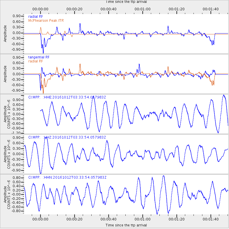
Signal To Noise
| Channel | StoN | STA | LTA |
| CI:MPP: :HHZ:20161012T03:33:54.057983Z | 3.149854 | 7.530507E-7 | 2.390748E-7 |
| CI:MPP: :HHN:20161012T03:33:54.057983Z | 0.7909925 | 3.7931358E-7 | 4.795413E-7 |
| CI:MPP: :HHE:20161012T03:33:54.057983Z | 1.9274977 | 7.531256E-7 | 3.907271E-7 |
| Arrivals |
| Ps | |
| PpPs | |
| PsPs/PpSs | |


