You are here: Home > Network List > TJ - Tajikistan National Seismic Network Stations List
> Station GARM Garm, Tajikistan > Earthquake Result Viewer
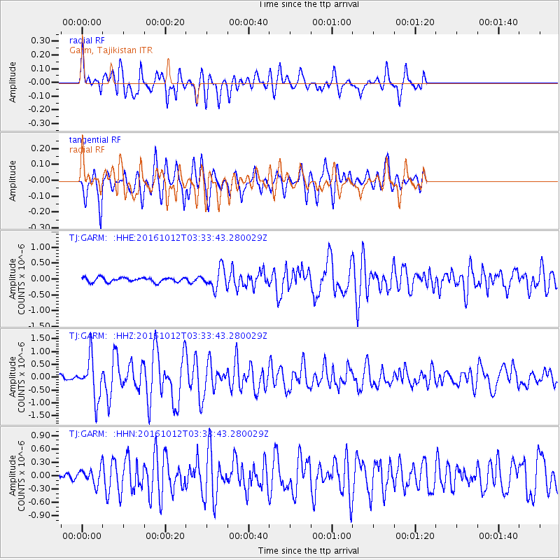
GARM Garm, Tajikistan - Earthquake Result Viewer
*The percent match for this event was below the threshold and hence no stack was calculated.
| Earthquake location: |
New Ireland Region, P.N.G. |
| Earthquake latitude/longitude: |
-5.4/153.5 |
| Earthquake time(UTC): |
2016/10/12 (286) 03:21:26 GMT |
| Earthquake Depth: |
22 km |
| Earthquake Magnitude: |
5.7 MB |
| Earthquake Catalog/Contributor: |
NEIC PDE/NEIC ALERT |
|
| Network: |
TJ Tajikistan National Seismic Network |
| Station: |
GARM Garm, Tajikistan |
| Lat/Lon: |
39.00 N/70.32 E |
| Elevation: |
1305 m |
|
| Distance: |
88.0 deg |
| Az: |
309.276 deg |
| Baz: |
98.448 deg |
| Ray Param: |
$rayparam |
*The percent match for this event was below the threshold and hence was not used in the summary stack. |
|
| Radial Match: |
65.43783 % |
| Radial Bump: |
400 |
| Transverse Match: |
64.789276 % |
| Transverse Bump: |
400 |
| SOD ConfigId: |
11737051 |
| Insert Time: |
2019-04-25 17:31:43.272 +0000 |
| GWidth: |
2.5 |
| Max Bumps: |
400 |
| Tol: |
0.001 |
|
Signal To Noise
| Channel | StoN | STA | LTA |
| TJ:GARM: :HHZ:20161012T03:33:43.280029Z | 7.378716 | 8.1732674E-7 | 1.1076815E-7 |
| TJ:GARM: :HHN:20161012T03:33:43.280029Z | 1.7142122 | 1.800415E-7 | 1.0502871E-7 |
| TJ:GARM: :HHE:20161012T03:33:43.280029Z | 4.486252 | 3.2154543E-7 | 7.167352E-8 |
| Arrivals |
| Ps | |
| PpPs | |
| PsPs/PpSs | |


