You are here: Home > Network List > BK - Berkeley Digital Seismograph Network Stations List
> Station CMB Columbia College, Columbia, CA > Earthquake Result Viewer
CMB Columbia College, Columbia, CA - Earthquake Result Viewer
| Earthquake location: |
East Of Kuril Islands |
| Earthquake latitude/longitude: |
46.9/155.2 |
| Earthquake time(UTC): |
2009/01/15 (015) 17:49:39 GMT |
| Earthquake Depth: |
36 km |
| Earthquake Magnitude: |
6.9 MB, 7.5 MS, 7.4 MW, 7.4 MW |
| Earthquake Catalog/Contributor: |
WHDF/NEIC |
|
| Network: |
BK Berkeley Digital Seismograph Network |
| Station: |
CMB Columbia College, Columbia, CA |
| Lat/Lon: |
38.03 N/120.39 W |
| Elevation: |
697 m |
|
| Distance: |
60.1 deg |
| Az: |
65.053 deg |
| Baz: |
308.002 deg |
| Ray Param: |
0.06169494 |
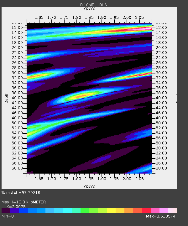
| Estimated Moho Depth: |
12.0 km |
| Estimated Crust Vp/Vs: |
2.10 |
| Assumed Crust Vp: |
6.597 km/s |
| Estimated Crust Vs: |
3.145 km/s |
| Estimated Crust Poisson's Ratio: |
0.35 |
|
| Radial Match: |
97.79319 % |
| Radial Bump: |
332 |
| Transverse Match: |
97.396454 % |
| Transverse Bump: |
371 |
| SOD ConfigId: |
2834 |
| Insert Time: |
2010-03-05 18:38:43.884 +0000 |
| GWidth: |
2.5 |
| Max Bumps: |
400 |
| Tol: |
0.001 |
|

Signal To Noise
| Channel | StoN | STA | LTA |
| BK:CMB: :BHN:20090115T17:59:11.947014Z | 68.716255 | 1.262581E-5 | 1.8373834E-7 |
| BK:CMB: :BHE:20090115T17:59:11.947014Z | 31.478107 | 3.4452503E-6 | 1.0944909E-7 |
| BK:CMB: :BHZ:20090115T17:59:11.947014Z | 28.311895 | 3.6368708E-6 | 1.2845734E-7 |
| Arrivals |
| Ps | 2.1 SECOND |
| PpPs | 5.4 SECOND |
| PsPs/PpSs | 7.5 SECOND |


