You are here: Home > Network List > TA - USArray Transportable Network (new EarthScope stations) Stations List
> Station 833A Chaparral WMA, Artesia Wells, TX, USA > Earthquake Result Viewer
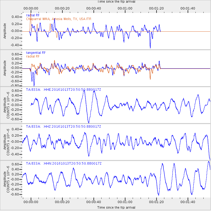
833A Chaparral WMA, Artesia Wells, TX, USA - Earthquake Result Viewer
*The percent match for this event was below the threshold and hence no stack was calculated.
| Earthquake location: |
Southeast Of Easter Island |
| Earthquake latitude/longitude: |
-35.5/-104.0 |
| Earthquake time(UTC): |
2016/10/13 (287) 20:40:51 GMT |
| Earthquake Depth: |
10 km |
| Earthquake Magnitude: |
5.0 mb |
| Earthquake Catalog/Contributor: |
NEIC PDE/us |
|
| Network: |
TA USArray Transportable Network (new EarthScope stations) |
| Station: |
833A Chaparral WMA, Artesia Wells, TX, USA |
| Lat/Lon: |
28.32 N/99.39 W |
| Elevation: |
171 m |
|
| Distance: |
63.6 deg |
| Az: |
4.539 deg |
| Baz: |
184.201 deg |
| Ray Param: |
$rayparam |
*The percent match for this event was below the threshold and hence was not used in the summary stack. |
|
| Radial Match: |
64.96361 % |
| Radial Bump: |
355 |
| Transverse Match: |
75.436066 % |
| Transverse Bump: |
367 |
| SOD ConfigId: |
11737051 |
| Insert Time: |
2019-04-25 17:47:53.069 +0000 |
| GWidth: |
2.5 |
| Max Bumps: |
400 |
| Tol: |
0.001 |
|
Signal To Noise
| Channel | StoN | STA | LTA |
| TA:833A: :HHZ:20161013T20:50:50.880017Z | 0.6759019 | 1.2885913E-7 | 1.9064768E-7 |
| TA:833A: :HHN:20161013T20:50:50.880017Z | 0.652665 | 1.2632928E-7 | 1.9355915E-7 |
| TA:833A: :HHE:20161013T20:50:50.880017Z | 1.8026025 | 3.7483295E-7 | 2.0793988E-7 |
| Arrivals |
| Ps | |
| PpPs | |
| PsPs/PpSs | |


