You are here: Home > Network List > BK - Berkeley Digital Seismograph Network Stations List
> Station CMB Columbia College, California, USA > Earthquake Result Viewer
CMB Columbia College, California, USA - Earthquake Result Viewer
| Earthquake location: |
Northern Colombia |
| Earthquake latitude/longitude: |
6.9/-76.8 |
| Earthquake time(UTC): |
1992/10/17 (291) 08:32:39 GMT |
| Earthquake Depth: |
10 km |
| Earthquake Magnitude: |
6.2 MB, 6.7 MS, 7.0 UNKNOWN |
| Earthquake Catalog/Contributor: |
WHDF/NEIC |
|
| Network: |
BK Berkeley Digital Seismograph Network |
| Station: |
CMB Columbia College, California, USA |
| Lat/Lon: |
38.03 N/120.39 W |
| Elevation: |
719 m |
|
| Distance: |
50.1 deg |
| Az: |
314.844 deg |
| Baz: |
116.93 deg |
| Ray Param: |
0.06825563 |
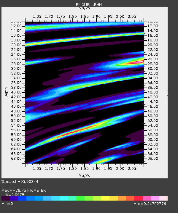
| Estimated Moho Depth: |
26.75 km |
| Estimated Crust Vp/Vs: |
2.10 |
| Assumed Crust Vp: |
6.597 km/s |
| Estimated Crust Vs: |
3.145 km/s |
| Estimated Crust Poisson's Ratio: |
0.35 |
|
| Radial Match: |
95.90844 % |
| Radial Bump: |
339 |
| Transverse Match: |
86.49592 % |
| Transverse Bump: |
400 |
| SOD ConfigId: |
16938 |
| Insert Time: |
2010-03-05 18:39:20.460 +0000 |
| GWidth: |
2.5 |
| Max Bumps: |
400 |
| Tol: |
0.001 |
|
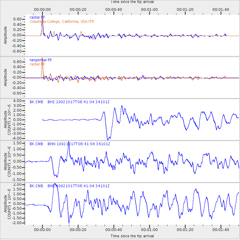
Signal To Noise
| Channel | StoN | STA | LTA |
| BK:CMB: :BHN:19921017T08:41:04.34101Z | 4.7561727 | 1.6707843E-7 | 3.5128753E-8 |
| BK:CMB: :BHE:19921017T08:41:04.34101Z | 4.590584 | 3.1715857E-7 | 6.908894E-8 |
| BK:CMB: :BHZ:19921017T08:41:04.34101Z | 10.916456 | 7.0949676E-7 | 6.499332E-8 |
| Arrivals |
| Ps | 4.7 SECOND |
| PpPs | 12 SECOND |
| PsPs/PpSs | 17 SECOND |


